IMAGES TAKEN NEAR TO
Cumbernauld, GLASGOW, G67 4AE
Introduction
This page details the photographs taken nearby to G67 4AE by members of the Geograph project.
The Geograph project started in 2005 with the aim of publishing, organising and preserving representative images for every square kilometre of Great Britain, Ireland and the Isle of Man.

There are currently over 7.5m images from over14,400 individuals and you can help contribute to the project by visiting https://www.geograph.org.uk
Image Map
Images are licensed for reuse under creativecommons.org/licenses/by-sa/2.0
Notes
- Clicking on the map will re-center to the selected point.
- The higher the marker number, the further away the image location is from the centre of the postcode.
Image Listing (4 Images Found)
Images are licensed for reuse under creativecommons.org/licenses/by-sa/2.0
Image
Details
Distance
1
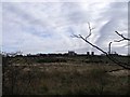
Glenhove Storage Reservoir
Underground storage facility for the supply of water to Cumbernauld.
Image: © Robert Murray
Taken: 12 Oct 2009
0.14 miles
2
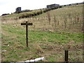
Coathill Farm Woodland
Recently planted Coathill Farm Woodland near Luggiebank
Image: © Iain Thompson
Taken: 16 Apr 2006
0.17 miles
3
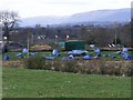
Adventure Activities, Easter Blairlinn
A venue for 'It's a Knockout' perhaps?
Image: © Robert Murray
Taken: 18 Apr 2010
0.19 miles
4
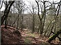
Forest track
In Muirhead Glen. This old woodland is being added to around the edges.
Image: © Robert Murray
Taken: 18 Apr 2010
0.23 miles