IMAGES TAKEN NEAR TO
Cumbernauld, GLASGOW, G67 4AA
Introduction
This page details the photographs taken nearby to G67 4AA by members of the Geograph project.
The Geograph project started in 2005 with the aim of publishing, organising and preserving representative images for every square kilometre of Great Britain, Ireland and the Isle of Man.

There are currently over 7.5m images from over14,400 individuals and you can help contribute to the project by visiting https://www.geograph.org.uk
Image Map
Images are licensed for reuse under creativecommons.org/licenses/by-sa/2.0
Notes
- Clicking on the map will re-center to the selected point.
- The higher the marker number, the further away the image location is from the centre of the postcode.
Image Listing (28 Images Found)
Images are licensed for reuse under creativecommons.org/licenses/by-sa/2.0
Image
Details
Distance
1
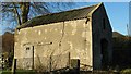
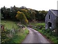
Old Farm Building at Glenhove
This old farm outbuilding probably dates back to the early 1800's.
The following information was provided by Moira:
"I have been told the old farm building was once a stable where the horse would go in the small door , the cart would go in the archway and the stableman would live in the area above (also has old steps running from the upstairs door to the downstairs stable)".
Image: © Texas Radio and The Big Beat
Taken: 28 Nov 2009
0.05 miles
2
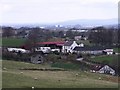
Glenhove Farm
More of a caravan parking yard these days maybe.
Image: © Robert Murray
Taken: 18 Apr 2010
0.05 miles
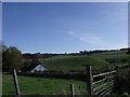
3
Glenhove Farm
Farmland surrounding Glenhove.
Image: © Jay Pea
Taken: 14 Mar 2023
0.05 miles
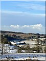
4
Glenhove cottage and drumlins
The hills south of the upper Luggie valley.
Image: © Robert Murray
Taken: 16 Oct 2009
0.07 miles
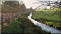
6
Bridge Over Cameron Burn at Glenhove
With Glenhove Farm buildings in the background.
Image: © Texas Radio and The Big Beat
Taken: 28 Nov 2009
0.08 miles
7
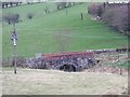
Bridge over Cameron Burn, Glenhove
A substantial bridge to accommodate a strong burn which can rise high and fast in spate.
Image: © Robert Murray
Taken: 18 Apr 2010
0.08 miles
8

Road Bridge at Glenhove
Spans the Luggie Water.
Image: © G Laird
Taken: 9 Jan 2014
0.09 miles
9
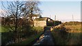
Road to Craigelvan
Across the bridge over the Cameron Burn and an old barn at Glenhove.
Image: © Robert Murray
Taken: 12 Oct 2009
0.09 miles
10
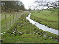
Cameron Burn at Glenhove
A short distance later it joins the Luggie.
Image: © Texas Radio and The Big Beat
Taken: 28 Nov 2009
0.09 miles