IMAGES TAKEN NEAR TO
Lime Crescent, GLASGOW, G67 3PQ
Introduction
This page details the photographs taken nearby to Lime Crescent, G67 3PQ by members of the Geograph project.
The Geograph project started in 2005 with the aim of publishing, organising and preserving representative images for every square kilometre of Great Britain, Ireland and the Isle of Man.

There are currently over 7.5m images from over14,400 individuals and you can help contribute to the project by visiting https://www.geograph.org.uk
Image Map
Images are licensed for reuse under creativecommons.org/licenses/by-sa/2.0
Notes
- Clicking on the map will re-center to the selected point.
- The higher the marker number, the further away the image location is from the centre of the postcode.
Image Listing (12 Images Found)
Images are licensed for reuse under creativecommons.org/licenses/by-sa/2.0
Image
Details
Distance
1
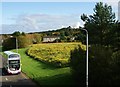
Wildflowers, Moss Road
This is one of many (and the largest) banks of wildflowers to be found
in the Abronhill area. They are also to be found in long strips at
various roundabouts and roadsides. They provide a welcome splash of colour
for much of the year.
See www.geograph.org.uk/photo/1657022 for a similar but much more wintery view from the same footbridge.
Image: © Texas Radio and The Big Beat
Taken: 16 Oct 2010
0.05 miles
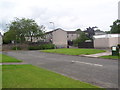
2
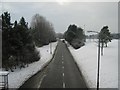
Moss Road, Abronhill
Looking west.
Image: © Texas Radio and The Big Beat
Taken: 9 Jan 2010
0.08 miles
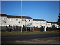
3
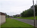
Moss Road
One of the main roads of Abronhill.
Image: © Ross Watson
Taken: 5 Aug 2013
0.10 miles
4
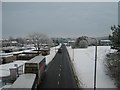
Moss Road, Abronhill
Looking east
Image: © Texas Radio and The Big Beat
Taken: 9 Jan 2010
0.12 miles
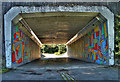
7
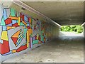
Abronhill Art
Underpass under Blackthorn Road with its funky new artwork.
Kind of grows on you after a bit.
Image: © Texas Radio and The Big Beat
Taken: 23 May 2010
0.14 miles
8
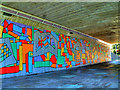
Bright Sight
This mural is on an underpass in Abronhill, Cumbernauld, Scotland. I had it published in my local paper the "Airdrie and Coatbridge Advertiser" on the 8th September 2010.
Image: © Stevie Spiers
Taken: 27 Aug 2010
0.15 miles
10
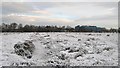
Abronhill Peat Bog
Between Abronhill High School and Blackthorn Road there is a large area
of peat bog. Aerial pictures show long, parallel lines which would indicate
that the peat has been cultivated sometime relatively recently.
Whether this was done before Abronhill was built or after I do not know
although I would assume it would have been before.
Abronhill High School in the distance.
Image: © Texas Radio and The Big Beat
Taken: 19 Dec 2009
0.18 miles