IMAGES TAKEN NEAR TO
Chestnut Place, GLASGOW, G67 3NW
Introduction
This page details the photographs taken nearby to Chestnut Place, G67 3NW by members of the Geograph project.
The Geograph project started in 2005 with the aim of publishing, organising and preserving representative images for every square kilometre of Great Britain, Ireland and the Isle of Man.

There are currently over 7.5m images from over14,400 individuals and you can help contribute to the project by visiting https://www.geograph.org.uk
Image Map
Images are licensed for reuse under creativecommons.org/licenses/by-sa/2.0
Notes
- Clicking on the map will re-center to the selected point.
- The higher the marker number, the further away the image location is from the centre of the postcode.
Image Listing (7 Images Found)
Images are licensed for reuse under creativecommons.org/licenses/by-sa/2.0
Image
Details
Distance
3
Broom Road, Abronhill
Formerly Slamannan Road.
Image: © Texas Radio and The Big Beat
Taken: 2 Apr 2010
0.22 miles
4
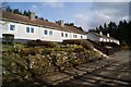
Broom Road Cottages
These are the original four Abronhill cottages.
They date from before the new town was built and were originally
constructed for the workers of the near by farms.
They are situated on the old Slamannan Road (now Broom Road).
Image: © Texas Radio and The Big Beat
Taken: 2 Apr 2010
0.22 miles
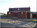
5
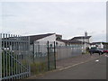
St. Lucy's Primary School
St. Lucy's Primary School, serving Abronhill.
Image: © Ross Watson
Taken: 5 Aug 2013
0.22 miles
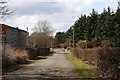
6
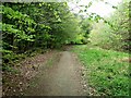
Track off Broom Road, Abronhill
An old drystane dyke runs along the side.
Image: © Robert Murray
Taken: 11 May 2010
0.23 miles
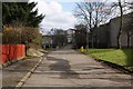
7
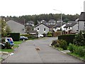
Birkenburn Road
A residential area in Cumbernauld.
Image: © Richard Webb
Taken: 14 Oct 2011
0.24 miles