IMAGES TAKEN NEAR TO
Chestnut Avenue, GLASGOW, G67 3NS
Introduction
This page details the photographs taken nearby to Chestnut Avenue, G67 3NS by members of the Geograph project.
The Geograph project started in 2005 with the aim of publishing, organising and preserving representative images for every square kilometre of Great Britain, Ireland and the Isle of Man.

There are currently over 7.5m images from over14,400 individuals and you can help contribute to the project by visiting https://www.geograph.org.uk
Image Map
Images are licensed for reuse under creativecommons.org/licenses/by-sa/2.0
Notes
- Clicking on the map will re-center to the selected point.
- The higher the marker number, the further away the image location is from the centre of the postcode.
Image Listing (8 Images Found)
Images are licensed for reuse under creativecommons.org/licenses/by-sa/2.0
Image
Details
Distance
1
Track off Broom Road, Abronhill
An old drystane dyke runs along the side.
Image: © Robert Murray
Taken: 11 May 2010
0.10 miles
2
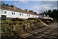
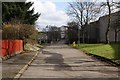
Broom Road Cottages
These are the original four Abronhill cottages.
They date from before the new town was built and were originally
constructed for the workers of the near by farms.
They are situated on the old Slamannan Road (now Broom Road).
Image: © Texas Radio and The Big Beat
Taken: 2 Apr 2010
0.12 miles
3
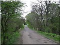
Broom Road, Abronhill
Formerly Slamannan Road.
Image: © Texas Radio and The Big Beat
Taken: 2 Apr 2010
0.14 miles
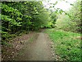
5
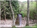
Broom Road to Abronhill
The Red Burn and the Glasgow - Falkirk railway run beneath.
Image: © Robert Murray
Taken: 11 May 2010
0.21 miles
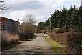
7
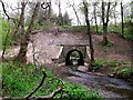
Red Burn tunnel
Not a tunnel in the true sense of the meaning but a bridge like structure built and then covered by the earth embankment above. A much favoured method of Victorian railway builders. The banking and tunnel would appear to have been built after the nearby Caledonian Railway line to Falkirk was built in c.1848 to carry the existing road on a level with the new bridge built over the railway 100m S.E.
Image: © Robert Murray
Taken: 11 May 2010
0.24 miles