IMAGES TAKEN NEAR TO
Cumbernauld, GLASGOW, G67 3JN
Introduction
This page details the photographs taken nearby to G67 3JN by members of the Geograph project.
The Geograph project started in 2005 with the aim of publishing, organising and preserving representative images for every square kilometre of Great Britain, Ireland and the Isle of Man.

There are currently over 7.5m images from over14,400 individuals and you can help contribute to the project by visiting https://www.geograph.org.uk
Image Map
Images are licensed for reuse under creativecommons.org/licenses/by-sa/2.0
Notes
- Clicking on the map will re-center to the selected point.
- The higher the marker number, the further away the image location is from the centre of the postcode.
Image Listing (12 Images Found)
Images are licensed for reuse under creativecommons.org/licenses/by-sa/2.0
Image
Details
Distance
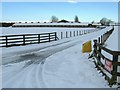
1
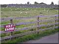
Kilt Farm
I took this photograph from Kilt Bridge.
Image: © Stevie Spiers
Taken: 25 Sep 2007
0.02 miles
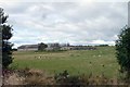
2
Kilt Farm and Cumbernauld
With the water tower at Carrickstone on the horizon.
Image: © Robert Murray
Taken: 13 Sep 2009
0.03 miles
4
Kilt Farm, Abronhill
This must be where they breed kilts.
Image: © Chris Upson
Taken: 30 Sep 2006
0.07 miles
5
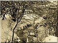
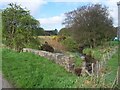
The Walton Burn
The Walton Burn, near Kilt Bridge, in December 2010.
Image: © Don Gillies
Taken: Unknown
0.14 miles

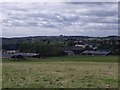
7
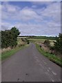
Cumbernauld, Kilt Brae
The burn flows under the road just a few yards in front.
Image: © Robert Murray
Taken: 13 Sep 2009
0.17 miles
8
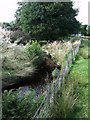
Cumbernauld, Walton Burn
After passing under Kilt bridge on its way to the Red Burn.
Image: © Robert Murray
Taken: 13 Sep 2009
0.18 miles
9
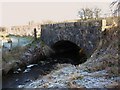
Kilt Bridge
Over the Walton Burn.
Image: © Texas Radio and The Big Beat
Taken: 31 Jan 2010
0.19 miles