IMAGES TAKEN NEAR TO
Medlar Road, GLASGOW, G67 3AG
Introduction
This page details the photographs taken nearby to Medlar Road, G67 3AG by members of the Geograph project.
The Geograph project started in 2005 with the aim of publishing, organising and preserving representative images for every square kilometre of Great Britain, Ireland and the Isle of Man.

There are currently over 7.5m images from over14,400 individuals and you can help contribute to the project by visiting https://www.geograph.org.uk
Image Map
Images are licensed for reuse under creativecommons.org/licenses/by-sa/2.0
Notes
- Clicking on the map will re-center to the selected point.
- The higher the marker number, the further away the image location is from the centre of the postcode.
Image Listing (2 Images Found)
Images are licensed for reuse under creativecommons.org/licenses/by-sa/2.0
Image
Details
Distance
2
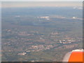
Central Scotland from the air
Looking northwest from over North Lanarkshire. The main built-up area across the lower centre is Cumbernauld; beyond and a little left is Kilsyth and beyond that are the Kilsyth Hills and the Carron Valley Reservoir.
Image: © M J Richardson
Taken: 5 Jul 2018
0.22 miles