IMAGES TAKEN NEAR TO
Glencryan Road, GLASGOW, G67 2UH
Introduction
This page details the photographs taken nearby to Glencryan Road, G67 2UH by members of the Geograph project.
The Geograph project started in 2005 with the aim of publishing, organising and preserving representative images for every square kilometre of Great Britain, Ireland and the Isle of Man.

There are currently over 7.5m images from over14,400 individuals and you can help contribute to the project by visiting https://www.geograph.org.uk
Image Map
Images are licensed for reuse under creativecommons.org/licenses/by-sa/2.0
Notes
- Clicking on the map will re-center to the selected point.
- The higher the marker number, the further away the image location is from the centre of the postcode.
Image Listing (10 Images Found)
Images are licensed for reuse under creativecommons.org/licenses/by-sa/2.0
Image
Details
Distance
1
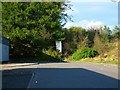
The end of the road, Cumbernauld
The blank end of Glencryan Road.
Image: © Robert Murray
Taken: 6 May 2010
0.05 miles
2
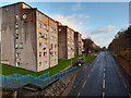
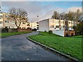
Housing at South Carbrain
Modernist New Town housing.
Image: © David Bremner
Taken: 9 Nov 2022
0.10 miles
3
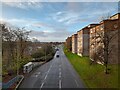
Housing at South Carbrain
Modernist New Town housing.
Image: © David Bremner
Taken: 9 Nov 2022
0.10 miles
4
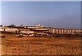
Carbrain from Lenziemill
Photograph from 1981. The waste ground in the foreground is now mostly industrial estate. Cumbernauld Railway Station is in the centre of the picture, with the houses of Carbrain behind. In the distance are the high-rise flats at Burns Road - Morrison House, Stuart House and Elliot House.
Image: © Robert Struthers
Taken: Unknown
0.12 miles
5
Housing at Carbrain
Modernist New Town housing.
Image: © David Bremner
Taken: 9 Nov 2022
0.14 miles
6
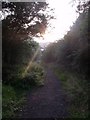
Cumbernauld Sunset
From the path leading up to Pallyrigg.
Image: © Robert Murray
Taken: 18 Sep 2009
0.18 miles
7
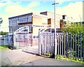
Carbrain Primary School
Main entrance.
Image: © Raymond Okonski
Taken: 16 May 2006
0.22 miles
8

Footpath to Greenrigg Road, Cumbernauld
Off an elevated path that parallels South Carbrain Road.
Image: © Richard Vince
Taken: 12 Sep 2022
0.24 miles
9
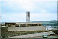
Kildrum Parish Church, Cumbernauld, 1963
One of two churches commissioned for the new town of Cumbernauld by the Church of Scotland, architect Alan Reiach, it opened in 1962. As can be seen the works were still not complete at the time of the visit. It was accorded category B Listing in 2000. See http://www.geograph.org.uk/photo/6424830 for a view of the interior.
Image: © Alan Murray-Rust
Taken: Unknown
0.24 miles
10
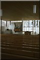
Kildrum Parish Church, Cumbernauld, 1964
Interior view looking towards the communion table. The cross behind this is installed in the garden outside the church, rather than inside the church. The design by Alan Reiach clearly shows the Scandinavian influences that were much favoured at the period. Opened in 1962, Listed Category B in 2000.
Image: © Alan Murray-Rust
Taken: Unknown
0.25 miles