IMAGES TAKEN NEAR TO
Lenziemill Road, GLASGOW, G67 2UD
Introduction
This page details the photographs taken nearby to Lenziemill Road, G67 2UD by members of the Geograph project.
The Geograph project started in 2005 with the aim of publishing, organising and preserving representative images for every square kilometre of Great Britain, Ireland and the Isle of Man.

There are currently over 7.5m images from over14,400 individuals and you can help contribute to the project by visiting https://www.geograph.org.uk
Image Map
Images are licensed for reuse under creativecommons.org/licenses/by-sa/2.0
Notes
- Clicking on the map will re-center to the selected point.
- The higher the marker number, the further away the image location is from the centre of the postcode.
Image Listing (23 Images Found)
Images are licensed for reuse under creativecommons.org/licenses/by-sa/2.0
Image
Details
Distance
1
Cumbernauld Sunset
From the path leading up to Pallyrigg.
Image: © Robert Murray
Taken: 18 Sep 2009
0.10 miles
2
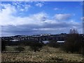
Cumbernauld, scrubland
With a good view of the town on the hillside.
Image: © Robert Murray
Taken: 18 Mar 2011
0.12 miles
3
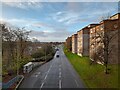
Housing at South Carbrain
Modernist New Town housing.
Image: © David Bremner
Taken: 9 Nov 2022
0.15 miles
4
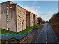
Housing at South Carbrain
Modernist New Town housing.
Image: © David Bremner
Taken: 9 Nov 2022
0.15 miles
5
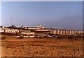
Carbrain from Lenziemill
Photograph from 1981. The waste ground in the foreground is now mostly industrial estate. Cumbernauld Railway Station is in the centre of the picture, with the houses of Carbrain behind. In the distance are the high-rise flats at Burns Road - Morrison House, Stuart House and Elliot House.
Image: © Robert Struthers
Taken: Unknown
0.15 miles
6
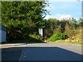
The end of the road, Cumbernauld
The blank end of Glencryan Road.
Image: © Robert Murray
Taken: 6 May 2010
0.17 miles
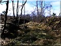
7
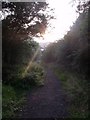
Glencryan tram road
Going downhill towards the old fireclay works it would seem the farmer erected a gate across the line. One wonders if he charged a toll?
Image: © Robert Murray
Taken: 18 Mar 2011
0.17 miles
8
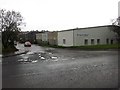
Briggs Amasco
Briggs Amasco make roofing for industrial buildings. This is an industrial area off Lenziemill Road, Cumbernauld.
Image: © Richard Webb
Taken: 18 Oct 2010
0.19 miles
9
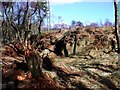
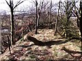
Glencryan woods
A piece of manufactured metal, a possible relic of the Glencryan tram road lies in the foreground and exposed rock in the background. On the horizon is a forest of blue plastic tubes containing the forest of the future.
Image: © Robert Murray
Taken: 18 Mar 2011
0.20 miles
10
Glencryan tram road
The path network veers away but the line of the old tram road can still be followed through this cutting.
Image: © Robert Murray
Taken: 18 Mar 2011
0.22 miles