IMAGES TAKEN NEAR TO
South Carbrain Ring Road, GLASGOW, G67 2UA
Introduction
This page details the photographs taken nearby to South Carbrain Ring Road, G67 2UA by members of the Geograph project.
The Geograph project started in 2005 with the aim of publishing, organising and preserving representative images for every square kilometre of Great Britain, Ireland and the Isle of Man.

There are currently over 7.5m images from over14,400 individuals and you can help contribute to the project by visiting https://www.geograph.org.uk
Image Map
Images are licensed for reuse under creativecommons.org/licenses/by-sa/2.0
Notes
- Clicking on the map will re-center to the selected point.
- The higher the marker number, the further away the image location is from the centre of the postcode.
Image Listing (45 Images Found)
Images are licensed for reuse under creativecommons.org/licenses/by-sa/2.0
Image
Details
Distance
1

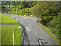
Footpath to Greenrigg Road, Cumbernauld
Off an elevated path that parallels South Carbrain Road.
Image: © Richard Vince
Taken: 12 Sep 2022
0.05 miles
2
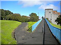
East end of Kilbowie Road, Cumbernauld
Seen from a footbridge just north of its junction with South Carbrain Road (behind the photographer). Kilbowie Road continues to the left, with Greenrigg Road heading off on the right.
Image: © Richard Vince
Taken: 12 Sep 2022
0.06 miles
3
Footpaths off Kilbowie Road, Cumbernauld
The path on the right climbs to a footbridge across the east end of Kilbowie Road, then continues parallel to South Carbrain Road (out of frame on the right, on the other side of the flats). The path on the left descends to meet Kilbowie Road opposite its junction with Greenrigg Road. Behind the photographer, the path joins the southern branch of Kilbowie Road.
Image: © Richard Vince
Taken: 12 Sep 2022
0.07 miles
4
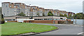
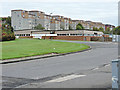
Flats on South Carbrain Road
The building in the foreground is Burroughs Social Club on Glencryan Road.
Image: © Thomas Nugent
Taken: 10 Oct 2015
0.07 miles
5
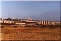
Carbrain from Lenziemill
Photograph from 1981. The waste ground in the foreground is now mostly industrial estate. Cumbernauld Railway Station is in the centre of the picture, with the houses of Carbrain behind. In the distance are the high-rise flats at Burns Road - Morrison House, Stuart House and Elliot House.
Image: © Robert Struthers
Taken: Unknown
0.10 miles
6
Flats on South Carbrain Road
The building in the foreground is Burroughs Social Club on Glencryan Road. Viewed from outside Cumbernauld railway station.
Image: © Thomas Nugent
Taken: 10 Oct 2015
0.10 miles
7

Turnback turned away
A diesel unit train from Glasgow, having terminated at Cumbernauld station, enters the turnback siding east of the station to stand clear of the main line. In due course, when the driver has changed ends, it will come out and use the crossover between the main lines to reach the station's westbound platform and return to Glasgow with another load of passengers. Today, instead of terminating at Cumbernauld, most trains continue along the main line towards Falkirk.
Image: © A-M-Jervis
Taken: 15 Oct 2005
0.10 miles
8

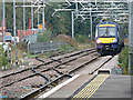
Cumbernauld railway station
The siding at the north end of the station where services which terminate at Cumbernauld are turned for the return journey.
Image: © Thomas Nugent
Taken: 10 Oct 2015
0.11 miles
9
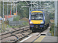
Train approaching Cumbernauld railway station
Scotrail Class 170 train number 170433 approaching with a Glasgow Queen Street service from Dunblane.
Image: © Thomas Nugent
Taken: 10 Oct 2015
0.11 miles
10
Train approaching Cumbernauld railway station
Scotrail Class 170 train number 170433 approaching with a Glasgow Queen Street service from Dunblane.
Image: © Thomas Nugent
Taken: 10 Oct 2015
0.11 miles