IMAGES TAKEN NEAR TO
Bluebell Walk, GLASGOW, G67 2TL
Introduction
This page details the photographs taken nearby to Bluebell Walk, G67 2TL by members of the Geograph project.
The Geograph project started in 2005 with the aim of publishing, organising and preserving representative images for every square kilometre of Great Britain, Ireland and the Isle of Man.

There are currently over 7.5m images from over14,400 individuals and you can help contribute to the project by visiting https://www.geograph.org.uk
Image Map
Images are licensed for reuse under creativecommons.org/licenses/by-sa/2.0
Notes
- Clicking on the map will re-center to the selected point.
- The higher the marker number, the further away the image location is from the centre of the postcode.
Image Listing (22 Images Found)
Images are licensed for reuse under creativecommons.org/licenses/by-sa/2.0
Image
Details
Distance

2
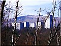
Cumbernauld, skyline
Aka Manhattan with Garrel Hill forming the horizon.
Image: © Robert Murray
Taken: 18 Mar 2011
0.09 miles
3
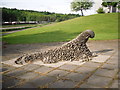
Pebbled Monster
This art work can be found in Cumbernauld Village.
Image: © Stevie Spiers
Taken: 28 May 2010
0.12 miles
4
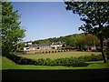
Cumbernauld Bowling Club
This bowling club can be found in Cumbernauld Village.
Image: © Stevie Spiers
Taken: 13 May 2009
0.12 miles
6
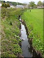
The Bogstank Burn
Flowing gently alongside the old Glasgow to Stirling Road. See also : Image
Image: © Robert Murray
Taken: 28 Apr 2010
0.19 miles

10
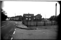
The Auld Road, Cumbernauld Village
Photo taken circa 1983
Image: © coughlan
Taken: Unknown
0.22 miles