IMAGES TAKEN NEAR TO
Main Street, GLASGOW, G67 2RY
Introduction
This page details the photographs taken nearby to Main Street, G67 2RY by members of the Geograph project.
The Geograph project started in 2005 with the aim of publishing, organising and preserving representative images for every square kilometre of Great Britain, Ireland and the Isle of Man.

There are currently over 7.5m images from over14,400 individuals and you can help contribute to the project by visiting https://www.geograph.org.uk
Image Map
Images are licensed for reuse under creativecommons.org/licenses/by-sa/2.0
Notes
- Clicking on the map will re-center to the selected point.
- The higher the marker number, the further away the image location is from the centre of the postcode.
Image Listing (44 Images Found)
Images are licensed for reuse under creativecommons.org/licenses/by-sa/2.0
Image
Details
Distance
1
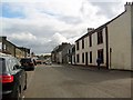
Village of Cumbernauld
Looking towards the Main Street.
Image: © Robert Murray
Taken: 28 Apr 2010
0.02 miles
2
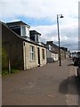
Baronhill, village of Cumbernauld
Looking towards Main Street.
Image: © Robert Murray
Taken: 28 Apr 2010
0.03 miles
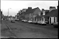
3

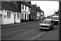
Main Street, Cumbernauld Village
Photo taken circa 1983.
Image: © coughlan
Taken: Unknown
0.04 miles
4
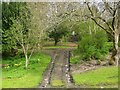
Lang Riggs
Another part of the riggs south of the village Main Street.
Image: © Robert Murray
Taken: 28 Apr 2010
0.05 miles
5
Main Street, Cumbernauld Village
Photo taken circa 1983
Image: © coughlan
Taken: Unknown
0.06 miles
6
Main Street, Cumbernauld Village
Photo taken circa 1983
Image: © coughlan
Taken: Unknown
0.06 miles
7

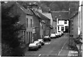
Smithyends, Cumbernauld Village
Photo taken circa 1983
Image: © coughlan
Taken: Unknown
0.07 miles
8

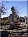
Cumbernauld Village War Memorial
Photo taken circa 1983
Image: © coughlan
Taken: Unknown
0.07 miles
10
The Wynd, Cumbernauld Village
Photo taken circa 1983
Image: © coughlan
Taken: Unknown
0.08 miles