IMAGES TAKEN NEAR TO
Wigtoun Place, GLASGOW, G67 2QZ
Introduction
This page details the photographs taken nearby to Wigtoun Place, G67 2QZ by members of the Geograph project.
The Geograph project started in 2005 with the aim of publishing, organising and preserving representative images for every square kilometre of Great Britain, Ireland and the Isle of Man.

There are currently over 7.5m images from over14,400 individuals and you can help contribute to the project by visiting https://www.geograph.org.uk
Image Map (Loading...)


Getting Data...Please wait
Leaflet Map data © OpenStreetMap
Images are licensed for reuse under creativecommons.org/licenses/by-sa/2.0
Notes
- Clicking on the map will re-center to the selected point.
- The higher the marker number, the further away the image location is from the centre of the postcode.
Image Listing (43 Images Found)
Images are licensed for reuse under creativecommons.org/licenses/by-sa/2.0
Image
Details
Distance
1
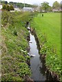
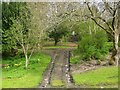
The Bogstank Burn
Flowing gently alongside the old Glasgow to Stirling Road. See also : Image
Image: © Robert Murray
Taken: 28 Apr 2010
0.06 miles
2
The Lang Riggs, Village of Cumbernauld
From the Cumbernauld Village blog www.cumbernauldvillage.org/
"The lang riggs on the south of the main street represent one of the most complete examples of a medieval pattern of land use in small communities where households would cultivate narrow strips of land for food. The lang riggs on this southern slope must have been lovely and sunny for growing fruit and vegetables. Today you can still see that pattern amongst the overgrown boundaries, some evidence of old dwellings and the old village wall. They are still a lovely place for a short work."
Image: © Robert Murray
Taken: 28 Apr 2010
0.08 miles
3
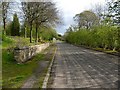
The auld road to Stirling, village of Cumbernauld
The Lang Riggs are to the left. This road hardly seems wide enough to be a trunk road (A80) but that's what it was until the mid 1960s.
Image: © Robert Murray
Taken: 28 Apr 2010
0.08 miles
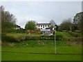
4
Cumbernauld Village Primary School
This building is not in use and I was informed by a local that it will be demolished to make way for new builds (flats or houses).
Image: © Stevie Spiers
Taken: 13 May 2009
0.12 miles
5
Lang Riggs
Another part of the riggs south of the village Main Street.
Image: © Robert Murray
Taken: 28 Apr 2010
0.12 miles
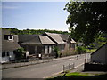
6

Masonic Temple
This building can be found in Cumbernauld Village, Cumbernauld.
Image: © Stevie Spiers
Taken: 13 May 2009
0.12 miles
7
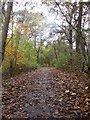
Footpath Near Park Way, Kildrum, Cumbernauld
Footpath running from Cumbernauld Theatre in the direction of Cumbernauld House
Image: © coughlan
Taken: 29 Oct 2012
0.13 miles
9
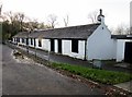
Cumbernauld Theatre
Cumbernauld Theatre was founded in 1960, utilising a set of abandoned farm cottages.
Image: © Euan Nelson
Taken: 6 Dec 2015
0.15 miles
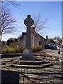
10

Cumbernauld Village War Memorial
Photo taken circa 1983
Image: © coughlan
Taken: Unknown
0.15 miles