IMAGES TAKEN NEAR TO
Kilbowie Road, GLASGOW, G67 2PX
Introduction
This page details the photographs taken nearby to Kilbowie Road, G67 2PX by members of the Geograph project.
The Geograph project started in 2005 with the aim of publishing, organising and preserving representative images for every square kilometre of Great Britain, Ireland and the Isle of Man.

There are currently over 7.5m images from over14,400 individuals and you can help contribute to the project by visiting https://www.geograph.org.uk
Image Map
Images are licensed for reuse under creativecommons.org/licenses/by-sa/2.0
Notes
- Clicking on the map will re-center to the selected point.
- The higher the marker number, the further away the image location is from the centre of the postcode.
Image Listing (45 Images Found)
Images are licensed for reuse under creativecommons.org/licenses/by-sa/2.0
Image
Details
Distance
1
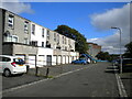
Southern part of Kilbowie Road, Cumbernauld
Image: © Richard Vince
Taken: 12 Sep 2022
0.07 miles
2
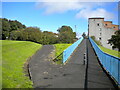
Footpaths off Kilbowie Road, Cumbernauld
The path on the right climbs to a footbridge across the east end of Kilbowie Road, then continues parallel to South Carbrain Road (out of frame on the right, on the other side of the flats). The path on the left descends to meet Kilbowie Road opposite its junction with Greenrigg Road. Behind the photographer, the path joins the southern branch of Kilbowie Road.
Image: © Richard Vince
Taken: 12 Sep 2022
0.07 miles
3
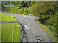
East end of Kilbowie Road, Cumbernauld
Seen from a footbridge just north of its junction with South Carbrain Road (behind the photographer). Kilbowie Road continues to the left, with Greenrigg Road heading off on the right.
Image: © Richard Vince
Taken: 12 Sep 2022
0.07 miles
4
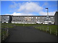
Footpath north of South Carbrain Road, Cumbernauld
Immediately north of Image, this path splits into three. The first left leads up to the pavement along the north side of South Carbrain Road; it is signposted as providing step free access to platform 1 of Cumbernauld railway station, which involves a lengthy journey to the footbridge at the west end of the station. The other two bits of the path lead to various bits of Kilbowie Road, onto the southern section of which the housing fronts.
Image: © Richard Vince
Taken: 12 Sep 2022
0.08 miles
5

Footpath to Greenrigg Road, Cumbernauld
Off an elevated path that parallels South Carbrain Road.
Image: © Richard Vince
Taken: 12 Sep 2022
0.09 miles
6

South Carbrain Road
Looking towards Cumbernauld railway station.
Image: © Thomas Nugent
Taken: 10 Oct 2015
0.10 miles
7
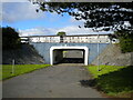
Subway under South Carbrain Road, Cumbernauld
Providing pedestrian access between the town and the railway station (behind the photographer). The houses beyond South Carbrain Road are on Kilbowie Road.
Image: © Richard Vince
Taken: 12 Sep 2022
0.10 miles
8
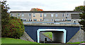
Pedestrian underpass
Under South Carbrain Road, near Cumbernauld railway station.
Image: © Thomas Nugent
Taken: 10 Oct 2015
0.11 miles
9
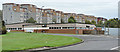
Flats on South Carbrain Road
The building in the foreground is Burroughs Social Club on Glencryan Road.
Image: © Thomas Nugent
Taken: 10 Oct 2015
0.12 miles
10
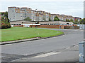
Flats on South Carbrain Road
The building in the foreground is Burroughs Social Club on Glencryan Road. Viewed from outside Cumbernauld railway station.
Image: © Thomas Nugent
Taken: 10 Oct 2015
0.12 miles