IMAGES TAKEN NEAR TO
Broomlands Road, GLASGOW, G67 2PU
Introduction
This page details the photographs taken nearby to Broomlands Road, G67 2PU by members of the Geograph project.
The Geograph project started in 2005 with the aim of publishing, organising and preserving representative images for every square kilometre of Great Britain, Ireland and the Isle of Man.

There are currently over 7.5m images from over14,400 individuals and you can help contribute to the project by visiting https://www.geograph.org.uk
Image Map
Images are licensed for reuse under creativecommons.org/licenses/by-sa/2.0
Notes
- Clicking on the map will re-center to the selected point.
- The higher the marker number, the further away the image location is from the centre of the postcode.
Image Listing (44 Images Found)
Images are licensed for reuse under creativecommons.org/licenses/by-sa/2.0
Image
Details
Distance
1
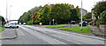
South Carbrain Road
At Broomlands Road.
Image: © Thomas Nugent
Taken: 10 Oct 2015
0.11 miles
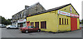
2
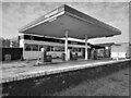
Study of a Gasoline Station
Highland, Cumbernauld.
This photograph is part of a series taken in homage to the American artist Ed Ruscha's 1963 publication of 'Twentysix Gasoline Stations'.
More properly known as filling stations in the UK, I am attempting to photograph as many as possible to mark the sixty year anniversary.
Image: © David Bremner
Taken: 16 May 2023
0.12 miles

4
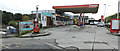
Thames petrol station
On South Carbrain Road at Station Buildings.
Image: © Thomas Nugent
Taken: 10 Oct 2015
0.12 miles
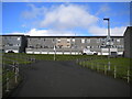
5

Carbrain Housing
A good example of the modernist style housing at Carbrain.
Image: © David Bremner
Taken: 16 May 2023
0.12 miles
6
Footpath north of South Carbrain Road, Cumbernauld
Immediately north of Image, this path splits into three. The first left leads up to the pavement along the north side of South Carbrain Road; it is signposted as providing step free access to platform 1 of Cumbernauld railway station, which involves a lengthy journey to the footbridge at the west end of the station. The other two bits of the path lead to various bits of Kilbowie Road, onto the southern section of which the housing fronts.
Image: © Richard Vince
Taken: 12 Sep 2022
0.12 miles
7
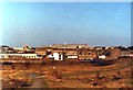
Carbrain from Lenziemill
Photographed in 1981. The waste ground in the foreground is now part-shrubland, part industrial estate. Cumbernauld Town Centre is on the skyline and the stone-built house on the right used to be a general store.
Image: © Robert Struthers
Taken: Unknown
0.13 miles
8
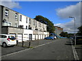
Southern part of Kilbowie Road, Cumbernauld
Image: © Richard Vince
Taken: 12 Sep 2022
0.13 miles
9
Station Buildings, Cumbernauld
One of very few older buildings in this area. Overlooking the railway station.
Image: © Thomas Nugent
Taken: 10 Oct 2015
0.13 miles
10

South Carbrain Road
Looking towards Cumbernauld railway station.
Image: © Thomas Nugent
Taken: 10 Oct 2015
0.14 miles