IMAGES TAKEN NEAR TO
Glenacre Road, GLASGOW, G67 2NT
Introduction
This page details the photographs taken nearby to Glenacre Road, G67 2NT by members of the Geograph project.
The Geograph project started in 2005 with the aim of publishing, organising and preserving representative images for every square kilometre of Great Britain, Ireland and the Isle of Man.

There are currently over 7.5m images from over14,400 individuals and you can help contribute to the project by visiting https://www.geograph.org.uk
Image Map
Images are licensed for reuse under creativecommons.org/licenses/by-sa/2.0
Notes
- Clicking on the map will re-center to the selected point.
- The higher the marker number, the further away the image location is from the centre of the postcode.
Image Listing (13 Images Found)
Images are licensed for reuse under creativecommons.org/licenses/by-sa/2.0
Image
Details
Distance
1

Footbridge over Jane's Brae
The bridge crosses a dual carriageway before depositing you in a maze of under building pathways off Glenacre Road. I am really looking forward to orienteering in Cumbernauld one day.
Image: © Richard Webb
Taken: 18 Oct 2010
0.10 miles
2

B8039 - Jane's Brae
Looking up to the split level interchange at North Carbrain Road (home of petrolheads?) from a footbridge between Glenacre Road and Abbotsford Road, Cumbernauld.
Image: © Richard Webb
Taken: 18 Oct 2010
0.11 miles
3
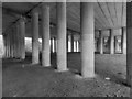
Langlands - Seafar Interchange
From the footpath that runs underneath. The photograph Hope's to display the structural beauty of concrete.
Image: © David Bremner
Taken: 16 May 2023
0.15 miles
4

Blue Bridge, Cumbernauld
Just one of dozens of blue pedestrian bridges linking up the warren of footpaths around Cumbernauld. This one flies over the B8039.
Image: © Chris Upson
Taken: 19 Aug 2006
0.18 miles
5
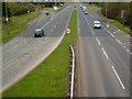
Central Way, Cumbernauld
A8011. The next square is just beyond the 50 MPH sign.
Image: © Robert Murray
Taken: 28 Apr 2010
0.18 miles
6
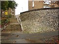
Ivanhoe to Abbotsford
Wattie Scott fans in this part of the town planning project. The steps link Abbotsford Road with Ivanhoe Road in Cumbernauld.
Image: © Richard Webb
Taken: 18 Oct 2010
0.19 miles
7

Carbrain Housing
A good example of the modernist style housing at Carbrain.
Image: © David Bremner
Taken: 16 May 2023
0.21 miles

9

Study of a Gasoline Station
Tesco Extra, Cumbernauld.
This photograph is part of a series taken in homage to the American artist Ed Ruscha's 1963 publication of 'Twentysix Gasoline Stations'.
More properly known as filling stations in the UK, I am attempting to photograph as many as possible to mark the sixty year anniversary.
Image: © David Bremner
Taken: 16 May 2023
0.22 miles
10
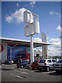
Wind Turbine
This unusual wind turbine can be found in Tesco's car park in Cumbernauld near Central Way.
Image: © Stevie Spiers
Taken: 20 May 2009
0.23 miles