IMAGES TAKEN NEAR TO
Clouden Road, GLASGOW, G67 2EP
Introduction
This page details the photographs taken nearby to Clouden Road, G67 2EP by members of the Geograph project.
The Geograph project started in 2005 with the aim of publishing, organising and preserving representative images for every square kilometre of Great Britain, Ireland and the Isle of Man.

There are currently over 7.5m images from over14,400 individuals and you can help contribute to the project by visiting https://www.geograph.org.uk
Image Map
Images are licensed for reuse under creativecommons.org/licenses/by-sa/2.0
Notes
- Clicking on the map will re-center to the selected point.
- The higher the marker number, the further away the image location is from the centre of the postcode.
Image Listing (7 Images Found)
Images are licensed for reuse under creativecommons.org/licenses/by-sa/2.0
Image
Details
Distance
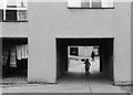
2
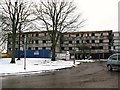
Maclehose Road Flats
Being prepared for demolition.
Image: © Texas Radio and The Big Beat
Taken: 4 Feb 2010
0.12 miles
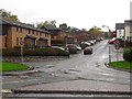
5
Cumbernauld housing ? 1964
Part of the Kyle Road development in the Kildrum area.
Image: © Alan Murray-Rust
Taken: Unknown
0.23 miles
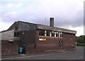
6
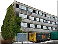
Flats on Ainslie Road
Ready for demolition.
Image: © Texas Radio and The Big Beat
Taken: 4 Feb 2010
0.24 miles
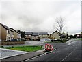
7
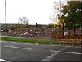
Demolished building. Cumbernauld
Rubble off Kildrum Road.
Image: © Richard Webb
Taken: 18 Oct 2010
0.25 miles