IMAGES TAKEN NEAR TO
Braehead Road, GLASGOW, G67 2BS
Introduction
This page details the photographs taken nearby to Braehead Road, G67 2BS by members of the Geograph project.
The Geograph project started in 2005 with the aim of publishing, organising and preserving representative images for every square kilometre of Great Britain, Ireland and the Isle of Man.

There are currently over 7.5m images from over14,400 individuals and you can help contribute to the project by visiting https://www.geograph.org.uk
Image Map
Images are licensed for reuse under creativecommons.org/licenses/by-sa/2.0
Notes
- Clicking on the map will re-center to the selected point.
- The higher the marker number, the further away the image location is from the centre of the postcode.
Image Listing (11 Images Found)
Images are licensed for reuse under creativecommons.org/licenses/by-sa/2.0
Image
Details
Distance
1
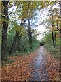
Footpath Near Park Way, Kildrum, Cumbernauld
This is very close to Cumbernauld Theatre
Image: © coughlan
Taken: 29 Oct 2012
0.07 miles
2
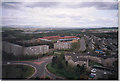
Kildrum 1992
Taken from the top of Stuart House, May 1992, looking North-East over Kildrum.
Image: © coughlan
Taken: 1 May 1992
0.08 miles
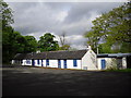
5
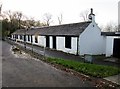
Cumbernauld Theatre
Cumbernauld Theatre was founded in 1960, utilising a set of abandoned farm cottages.
Image: © Euan Nelson
Taken: 6 Dec 2015
0.11 miles
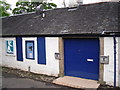
6
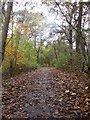
Footpath Near Park Way, Kildrum, Cumbernauld
Footpath running from Cumbernauld Theatre in the direction of Cumbernauld House
Image: © coughlan
Taken: 29 Oct 2012
0.12 miles
7
Kildrum Road, Cumbernauld, 1963
The town was very much a construction site in many places at the time of my visit. The maisonette blocks have since been replaced by new blocks on the lod layout.
Of particular interest is the lady wheeling a child in a pram along a major road, clearly not having got used to the presence of a network of pedestrian ways designed to keep pedestrians and traffic separated.
Image: © Alan Murray-Rust
Taken: Unknown
0.13 miles
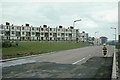
8

Kildrum Road
With the soon to be demolished flats on Ainslie Road on the left.
To see the demolished buildings www.geograph.org.uk/photo/1946569
Image: © Texas Radio and The Big Beat
Taken: 4 Feb 2010
0.16 miles
9
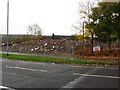
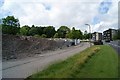
Demolished building. Cumbernauld
Rubble off Kildrum Road.
Image: © Richard Webb
Taken: 18 Oct 2010
0.18 miles
10
Kildrum Road
The flats on Ainslie Road are now demolished.
See www.geograph.org.uk/photo/1692744
Image: © Texas Radio and The Big Beat
Taken: 4 Jul 2010
0.21 miles