IMAGES TAKEN NEAR TO
Belstane Road, GLASGOW, G67 2AZ
Introduction
This page details the photographs taken nearby to Belstane Road, G67 2AZ by members of the Geograph project.
The Geograph project started in 2005 with the aim of publishing, organising and preserving representative images for every square kilometre of Great Britain, Ireland and the Isle of Man.

There are currently over 7.5m images from over14,400 individuals and you can help contribute to the project by visiting https://www.geograph.org.uk
Image Map
Images are licensed for reuse under creativecommons.org/licenses/by-sa/2.0
Notes
- Clicking on the map will re-center to the selected point.
- The higher the marker number, the further away the image location is from the centre of the postcode.
Image Listing (8 Images Found)
Images are licensed for reuse under creativecommons.org/licenses/by-sa/2.0
Image
Details
Distance
1

Stag
This wire constructed stag can be found at the entrance to an Industrial Estate on Blairlinn Road, Cumbernauld.
Image: © Stevie Spiers
Taken: 17 May 2009
0.12 miles
2
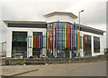
Highland Colour Coaters Extension (under construction) 2
Very near completion.
The vertical coloured tubes are actually organ pipes which are
connected to a huge organ housed inside. Every day at twelve pm,
they belt out a rendition of Scotland The Brave, which can be
heard for miles.
"Hark when the night is falling
Hear! Hear the pipes are calling....."
Also see... www.geograph.org.uk/photo/2112958
Image: © Texas Radio and The Big Beat
Taken: 21 May 2011
0.12 miles
3
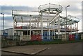
Highland Colour Coaters Extension (under construction) 1
This picture was taken in October 2010.
For a look at how the building looks near completion, see... www.geograph.org.uk/photo/2419306
Image: © Texas Radio and The Big Beat
Taken: 15 Oct 2010
0.12 miles
4
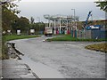
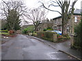
Blairlinn Road, Luggiebank
Serves an industrial estate. Highland Colour Coaters have a building under construction.
Image: © Richard Webb
Taken: 18 Oct 2010
0.13 miles
5
Old Lane, Luggiebank
This lane used to run from Luggiebank to Clayslope and Mid Blairlinn farms.
The farms are now gone (demolished when Blairlinn Ind Est was built)
and the lane is now an access road to many of the village's newer houses.
Image: © Texas Radio and The Big Beat
Taken: 16 Jan 2010
0.20 miles
6
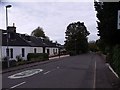
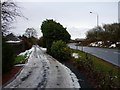
Stirling Road, Luggiebank
There is only one road and a pillar box in this delightful village.
Image: © Robert Murray
Taken: 12 Oct 2009
0.24 miles
7
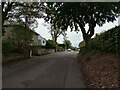
Stirling Road, Luggiebank
The quiet village of Luggiebank has been bypassed since the mid 1960s.
Image: © G Laird
Taken: 5 Jan 2014
0.24 miles
8
Stirling Road Luggiebank
Now blocked off just behind this viewpoint
Image: © Jim Smillie
Taken: 30 Sep 2023
0.24 miles