IMAGES TAKEN NEAR TO
Darroch Way, GLASGOW, G67 1QB
Introduction
This page details the photographs taken nearby to Darroch Way, G67 1QB by members of the Geograph project.
The Geograph project started in 2005 with the aim of publishing, organising and preserving representative images for every square kilometre of Great Britain, Ireland and the Isle of Man.

There are currently over 7.5m images from over14,400 individuals and you can help contribute to the project by visiting https://www.geograph.org.uk
Image Map
Images are licensed for reuse under creativecommons.org/licenses/by-sa/2.0
Notes
- Clicking on the map will re-center to the selected point.
- The higher the marker number, the further away the image location is from the centre of the postcode.
Image Listing (18 Images Found)
Images are licensed for reuse under creativecommons.org/licenses/by-sa/2.0
Image
Details
Distance
1
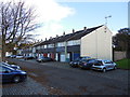
Darroch Way, Cumbernauld
Darroch Way, Seafar, Cumbernauld
Image: © coughlan
Taken: 26 Oct 2012
0.08 miles
2
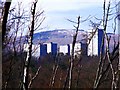
Cumbernauld, skyline
Aka Manhattan with Garrel Hill forming the horizon.
Image: © Robert Murray
Taken: 18 Mar 2011
0.09 miles
3
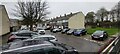
Darroch Way, Cumbernauld
Darroch Way, Seafar, Cumbernauld.
Image: © coughlan
Taken: 5 Nov 2022
0.09 miles
4
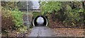
Pedestrian Tunnel Near Darroch Way, Cumbernauld
This is a pedestrian tunnel under the Seafar ring-road, near to Darroch Way. The footpath leads, ultimately, to the Cumbernauld Centre.
Image: © coughlan
Taken: 5 Nov 2022
0.10 miles
5
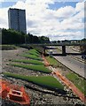
Cumbernauld's Light Sculpture
Part of the Cumbernauld Positive Image Campaign.
"The special effects are achieved by fins positioned on the embankments
of at A8011 - the approach road to the town centre. The intention is to
emulate the feeling of driving alongside a giant wave." Cumbernauld News.
See also www.geograph.org.uk/photo/2039476
Image: © Texas Radio and The Big Beat
Taken: 29 Aug 2010
0.15 miles
6
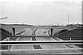
Braehead Roundabout over Central Way, Cumbernauld ? 1964
Central Way (A8011) is the principal spine road of the new town. Since this view, a tower block arose on the left hand side https://www.geograph.org.uk/photo/2039507 , but remarkably this has since been demolished to provide a similar skyline in 2019 (bar some tree growth) https://goo.gl/maps/xt2zTZH2ZMngLhri9
Image: © Alan Murray-Rust
Taken: Unknown
0.16 miles
7
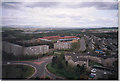
Kildrum 1992
Taken from the top of Stuart House, May 1992, looking North-East over Kildrum.
Image: © coughlan
Taken: 1 May 1992
0.18 miles
8
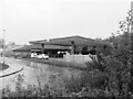
Study of a Gasoline Station
BP, Cumbernauld.
This photograph is part of a series taken in homage to the American artist Ed Ruscha's 1963 publication of 'Twentysix Gasoline Stations'.
More properly known as filling stations in the UK, I am attempting to photograph as many as possible to mark the sixty year anniversary.
Image: © David Bremner
Taken: 10 Oct 2023
0.19 miles
9
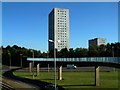
The Snake Bridge
This footbridge can be found in Cumbernauld, Scotland. The bridge takes pedestrians from Seafar to Kildrum and it crosses the A8011, I liked the shadow of the bridge on the ground to the left, it shows us the shape of the bridge, Cumbernauld has many blue coloured footbridges that cross main roads. The tower block at the other side of the bridge is called Stuart House.
Image: © Stevie Spiers
Taken: 1 Oct 2007
0.20 miles
10
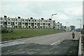
Kildrum Road, Cumbernauld, 1963
The town was very much a construction site in many places at the time of my visit. The maisonette blocks have since been replaced by new blocks on the lod layout.
Of particular interest is the lady wheeling a child in a pram along a major road, clearly not having got used to the presence of a network of pedestrian ways designed to keep pedestrians and traffic separated.
Image: © Alan Murray-Rust
Taken: Unknown
0.21 miles