IMAGES TAKEN NEAR TO
Ronaldsay Place, GLASGOW, G67 1NP
Introduction
This page details the photographs taken nearby to Ronaldsay Place, G67 1NP by members of the Geograph project.
The Geograph project started in 2005 with the aim of publishing, organising and preserving representative images for every square kilometre of Great Britain, Ireland and the Isle of Man.

There are currently over 7.5m images from over14,400 individuals and you can help contribute to the project by visiting https://www.geograph.org.uk
Image Map
Images are licensed for reuse under creativecommons.org/licenses/by-sa/2.0
Notes
- Clicking on the map will re-center to the selected point.
- The higher the marker number, the further away the image location is from the centre of the postcode.
Image Listing (10 Images Found)
Images are licensed for reuse under creativecommons.org/licenses/by-sa/2.0
Image
Details
Distance
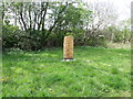
1
![Cumbernauld, Ravenswood Local Nature Reserve [2]](https://s1.geograph.org.uk/geophotos/02/95/51/2955101_4a8a9f33_120x120.jpg)
Cumbernauld, Ravenswood Local Nature Reserve [2]
Totem pole cut and carved (by a North Lanarkshire Council team) from the trunk of an Oak which fell during one of the big storms of the 2011/12 winter.
Image: © Robert Murray
Taken: 20 May 2012
0.11 miles
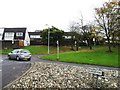
2
Cumbernauld, Ravenswood Local Nature Reserve
At the entrance to the reserve the carving on this timber says; 'Brian Miller he loved this place'.
Image: © Robert Murray
Taken: 20 May 2012
0.12 miles
3
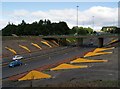
Cumbernauld's Light Sculpture
Part of the Cumbernauld Positive Image Campaign.
"The special effects are achieved by fins positioned on the embankments
of at A8011 - the approach road to the town centre. The intention is to
emulate the feeling of driving alongside a giant wave." Cumbernauld News.
See also www.geograph.org.uk/photo/2039507
Image: © Texas Radio and The Big Beat
Taken: 29 Aug 2010
0.16 miles
4
![Cumbernauld, Ravenswood Local Nature Reserve [3]](https://s1.geograph.org.uk/geophotos/02/95/51/2955121_463c1b76_120x120.jpg)
Cumbernauld, Ravenswood Local Nature Reserve [3]
Winding path.
Image: © Robert Murray
Taken: 20 May 2012
0.18 miles
5
![Cumbernauld, Ravenswood Local Nature Reserve [5]](https://s2.geograph.org.uk/geophotos/02/95/51/2955150_7c5c3b65_120x120.jpg)
Cumbernauld, Ravenswood Local Nature Reserve [5]
An almost dried up scrape out that is supposed to be an attempt to provide a habitat for wildlife. Scraping out a big shallow trench where the bed is a heavy gray mud will not encourage wildfowl. Someone needs to try a wee bit harder on the basics.
Image: © Robert Murray
Taken: 20 May 2012
0.20 miles
6
![Cumbernauld, Ravenswood Local Nature Reserve [12]](https://s3.geograph.org.uk/geophotos/02/95/65/2956587_c2a741b9_120x120.jpg)
Cumbernauld, Ravenswood Local Nature Reserve [12]
Shallow pond with tadpoles population.
Image: © Robert Murray
Taken: 20 May 2012
0.21 miles
7
![Cumbernauld, Ravenswood Local Nature Reserve [4]](https://s1.geograph.org.uk/geophotos/02/95/51/2955149_3d3b046b_120x120.jpg)
Cumbernauld, Ravenswood Local Nature Reserve [4]
This flat area must be the 'wetlands' bit the council publicity refers to. Sadly on this visit it was pretty dry.
Image: © Robert Murray
Taken: 20 May 2012
0.21 miles
9
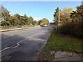
A8011: Glasgow Road
Linking Cumbernauld town centre with the M80 Glasgow-Stirling
Image: © Jim Smillie
Taken: 14 Oct 2023
0.24 miles
10
![Cumbernauld, Ravenswood Local Nature Reserve [15]](https://s1.geograph.org.uk/geophotos/02/95/66/2956621_bdde2df1_120x120.jpg)
Cumbernauld, Ravenswood Local Nature Reserve [15]
A large flat central part of the nature reserve which appears to be part bog, part rushes and part scrubby but firm ground is called the Orchid Meadow. Parts of the town can be seen beyond.
Image: © Robert Murray
Taken: 20 May 2012
0.25 miles