IMAGES TAKEN NEAR TO
Mactaggart Road, GLASGOW, G67 1JL
Introduction
This page details the photographs taken nearby to Mactaggart Road, G67 1JL by members of the Geograph project.
The Geograph project started in 2005 with the aim of publishing, organising and preserving representative images for every square kilometre of Great Britain, Ireland and the Isle of Man.

There are currently over 7.5m images from over14,400 individuals and you can help contribute to the project by visiting https://www.geograph.org.uk
Image Map
Images are licensed for reuse under creativecommons.org/licenses/by-sa/2.0
Notes
- Clicking on the map will re-center to the selected point.
- The higher the marker number, the further away the image location is from the centre of the postcode.
Image Listing (8 Images Found)
Images are licensed for reuse under creativecommons.org/licenses/by-sa/2.0
Image
Details
Distance
1
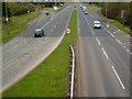
Central Way, Cumbernauld
A8011. The next square is just beyond the 50 MPH sign.
Image: © Robert Murray
Taken: 28 Apr 2010
0.09 miles
2
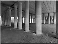
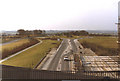
Langlands - Seafar Interchange
From the footpath that runs underneath. The photograph Hope's to display the structural beauty of concrete.
Image: © David Bremner
Taken: 16 May 2023
0.09 miles
3

Blue Bridge, Cumbernauld
Just one of dozens of blue pedestrian bridges linking up the warren of footpaths around Cumbernauld. This one flies over the B8039.
Image: © Chris Upson
Taken: 19 Aug 2006
0.10 miles
5
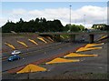
Cumbernauld's Light Sculpture
Part of the Cumbernauld Positive Image Campaign.
"The special effects are achieved by fins positioned on the embankments
of at A8011 - the approach road to the town centre. The intention is to
emulate the feeling of driving alongside a giant wave." Cumbernauld News.
See also www.geograph.org.uk/photo/2039507
Image: © Texas Radio and The Big Beat
Taken: 29 Aug 2010
0.18 miles
6
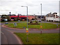
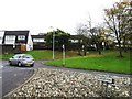
Cumbernauld Town Centre west roundabout
Very well designed and maintained roundabout. The backdrop is a legacy of inept politicians and 70s & 80s architects and town planners.
Image: © Robert Murray
Taken: 28 Apr 2010
0.23 miles
7
Central Way approaching Cumbernauld Town Centre
Taken in Spring 1981.
Image: © Robert Struthers
Taken: Unknown
0.24 miles
8

B8039 - Jane's Brae
Looking up to the split level interchange at North Carbrain Road (home of petrolheads?) from a footbridge between Glenacre Road and Abbotsford Road, Cumbernauld.
Image: © Richard Webb
Taken: 18 Oct 2010
0.24 miles