IMAGES TAKEN NEAR TO
Garrell Way, GLASGOW, G67 1HL
Introduction
This page details the photographs taken nearby to Garrell Way, G67 1HL by members of the Geograph project.
The Geograph project started in 2005 with the aim of publishing, organising and preserving representative images for every square kilometre of Great Britain, Ireland and the Isle of Man.

There are currently over 7.5m images from over14,400 individuals and you can help contribute to the project by visiting https://www.geograph.org.uk
Image Map
Images are licensed for reuse under creativecommons.org/licenses/by-sa/2.0
Notes
- Clicking on the map will re-center to the selected point.
- The higher the marker number, the further away the image location is from the centre of the postcode.
Image Listing (15 Images Found)
Images are licensed for reuse under creativecommons.org/licenses/by-sa/2.0
Image
Details
Distance
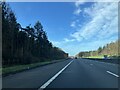
1
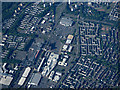
Cumbernauld town centre from the air
Viewed from a Prague bound flight from Glasgow.
Image: © Thomas Nugent
Taken: 5 Jun 2016
0.11 miles
2
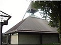
St Mungo's Church, Cumbernauld
St Mungo's Church is very Modernist, however, it is not as unpopular as its neighbour, the infamous Cumbernauld Town Centre!
Image: © GaryReggae
Taken: 25 Sep 2006
0.16 miles
4
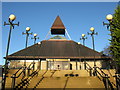
St Mungo's Church of Scotland
St Mungo's Church is a striking landmark in the centre of Cumbernauld, in stark contrast to the adjacent shopping centre which is often regarded as one of the ugliest town centres in the United Kingdom.
Image: © G Laird
Taken: 9 Jan 2014
0.22 miles
6
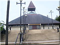
St. Mungo's Church of Scotland
The Cumbernauld church on St. Mungo's Road.
Image: © Ross Watson
Taken: 5 Aug 2013
0.22 miles
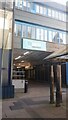
7
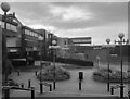
Cumbernauld Town Centre
A view of the modernist Town Centre. A masterpiece of architecture- at least I think so!
Image: © David Bremner
Taken: 10 Oct 2023
0.22 miles
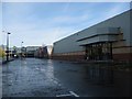
8
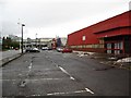
Abandoned Retail and Leisure Units
This part of Cumbernauld town centre has become forgotten and neglected.
Only one unit in this row was occupied when the picture was taken.
B&Q left their premises here around three years ago to move to Wardpark (Westway)
and who can hazard a guess when the Icehouse closed? Twenty-odd years ago?
See www.geograph.org.uk/photo/2139883 for picture and update from Nov 2010.
Image: © Texas Radio and The Big Beat
Taken: 16 Jan 2010
0.23 miles
9
An urban hill top
Somewhere near a minor summit on the East-West Watershed there is a portal to the Underworld, or Cumbernauld Shopping Centre.
Image: © Richard Webb
Taken: 28 Oct 2020
0.23 miles
10
Old B&Q Premises (under development)
From B&Q to B&M. Well that's who I'm reliably informed will be
taking over this huge retail unit. See www.geograph.org.uk/photo/1665081 for picture from earlier this year
Image: © Texas Radio and The Big Beat
Taken: 31 Oct 2010
0.23 miles