IMAGES TAKEN NEAR TO
Allanfauld Road, GLASGOW, G67 1EZ
Introduction
This page details the photographs taken nearby to Allanfauld Road, G67 1EZ by members of the Geograph project.
The Geograph project started in 2005 with the aim of publishing, organising and preserving representative images for every square kilometre of Great Britain, Ireland and the Isle of Man.

There are currently over 7.5m images from over14,400 individuals and you can help contribute to the project by visiting https://www.geograph.org.uk
Image Map
Images are licensed for reuse under creativecommons.org/licenses/by-sa/2.0
Notes
- Clicking on the map will re-center to the selected point.
- The higher the marker number, the further away the image location is from the centre of the postcode.
Image Listing (11 Images Found)
Images are licensed for reuse under creativecommons.org/licenses/by-sa/2.0
Image
Details
Distance
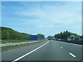
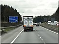
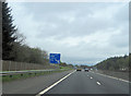
2
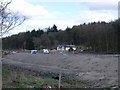
Cumbernauld, A80/M80 land works
At Eastfield/Seafar.
Image: © Robert Murray
Taken: 21 Apr 2010
0.18 miles
5
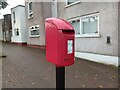
Postbox at Cumbernauld
G67 493. Royal Mail list this box as 'Fleming Road D'.
Image: © David Bremner
Taken: 10 Oct 2023
0.21 miles
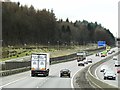
6
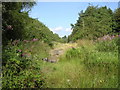
Course of old Cumbernauld to Glasgow road
Route for Cumbernauld to Glasgow road before A80 by-pass.
Image: © Chris Upson
Taken: 19 Aug 2006
0.21 miles
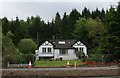
7

Seafar Housing
Modernist New Town housing.
Image: © David Bremner
Taken: 10 Oct 2023
0.21 miles
9

Arria
My favourite of Andy Scott's excellent public sculptures.
Image: © David Bremner
Taken: 9 Nov 2022
0.23 miles