IMAGES TAKEN NEAR TO
Mitchison Road, GLASGOW, G67 1AN
Introduction
This page details the photographs taken nearby to Mitchison Road, G67 1AN by members of the Geograph project.
The Geograph project started in 2005 with the aim of publishing, organising and preserving representative images for every square kilometre of Great Britain, Ireland and the Isle of Man.

There are currently over 7.5m images from over14,400 individuals and you can help contribute to the project by visiting https://www.geograph.org.uk
Image Map
Images are licensed for reuse under creativecommons.org/licenses/by-sa/2.0
Notes
- Clicking on the map will re-center to the selected point.
- The higher the marker number, the further away the image location is from the centre of the postcode.
Image Listing (14 Images Found)
Images are licensed for reuse under creativecommons.org/licenses/by-sa/2.0
Image
Details
Distance
1
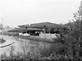
Study of a Gasoline Station
BP, Cumbernauld.
This photograph is part of a series taken in homage to the American artist Ed Ruscha's 1963 publication of 'Twentysix Gasoline Stations'.
More properly known as filling stations in the UK, I am attempting to photograph as many as possible to mark the sixty year anniversary.
Image: © David Bremner
Taken: 10 Oct 2023
0.09 miles
2
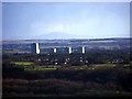
Cumbernauld and the Tinto
The 1960s tower blocks of Seafar and Kildrum in Cumbernauld are faintly framed by the Tinto http://en.wikipedia.org/wiki/Tinto 30 miles away to the south.
Image: © Robert Murray
Taken: 26 Feb 2011
0.11 miles
3
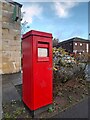
Postbox at Cumbernauld
G67 30. Royal Mail list this box as 'G67 South Muirhead Road'
Image: © David Bremner
Taken: 9 Nov 2022
0.14 miles
4
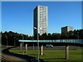
The Snake Bridge
This footbridge can be found in Cumbernauld, Scotland. The bridge takes pedestrians from Seafar to Kildrum and it crosses the A8011, I liked the shadow of the bridge on the ground to the left, it shows us the shape of the bridge, Cumbernauld has many blue coloured footbridges that cross main roads. The tower block at the other side of the bridge is called Stuart House.
Image: © Stevie Spiers
Taken: 1 Oct 2007
0.20 miles
5
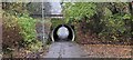
Pedestrian Tunnel Near Darroch Way, Cumbernauld
This is a pedestrian tunnel under the Seafar ring-road, near to Darroch Way. The footpath leads, ultimately, to the Cumbernauld Centre.
Image: © coughlan
Taken: 5 Nov 2022
0.20 miles
6
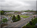
Exiting Central Way, Cumbernauld
This view is from Flemming House, the brown coloured building in the middle of the photograph is Cumbernauld Police Station which is on South Muirhead Road.
Image: © Stevie Spiers
Taken: 15 May 2009
0.20 miles
7
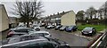
Darroch Way, Cumbernauld
Darroch Way, Seafar, Cumbernauld.
Image: © coughlan
Taken: 5 Nov 2022
0.21 miles
8
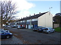
Darroch Way, Cumbernauld
Darroch Way, Seafar, Cumbernauld
Image: © coughlan
Taken: 26 Oct 2012
0.22 miles

10
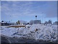
Cumbernauld, cleared snow
The Asda car park finally ploughed on day 6 of the early winter snows.
Image: © Robert Murray
Taken: 2 Dec 2010
0.23 miles