IMAGES TAKEN NEAR TO
Viewfield Avenue, GLASGOW, G66 8HB
Introduction
This page details the photographs taken nearby to Viewfield Avenue, G66 8HB by members of the Geograph project.
The Geograph project started in 2005 with the aim of publishing, organising and preserving representative images for every square kilometre of Great Britain, Ireland and the Isle of Man.

There are currently over 7.5m images from over14,400 individuals and you can help contribute to the project by visiting https://www.geograph.org.uk
Image Map
Images are licensed for reuse under creativecommons.org/licenses/by-sa/2.0
Notes
- Clicking on the map will re-center to the selected point.
- The higher the marker number, the further away the image location is from the centre of the postcode.
Image Listing (4 Images Found)
Images are licensed for reuse under creativecommons.org/licenses/by-sa/2.0
Image
Details
Distance
1
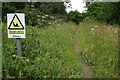
The way into Red Moss
The pathway leads from the corner of Red Moss Road and Laburnum Drive to a large area of grassland and scrub. The warning sign seems a bit over dramatic for this particular location.
Image: © Richard Sutcliffe
Taken: 14 Jul 2019
0.07 miles
2
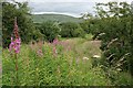
Red Moss
A clump of rosebay willowherb, Chamerion angustifolium, in amongst the grassland and scrub of Red Moss to the west of Milton of Campsie.
Image: © Richard Sutcliffe
Taken: 14 Jul 2019
0.19 miles
3
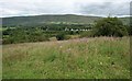
Red Moss grassland
Looking north towards the Campsie Fells.
Image: © Richard Sutcliffe
Taken: 14 Jul 2019
0.19 miles
4
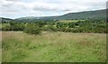
Red Moss grassland
Looking northwest towards Lennoxtown and Campsie Glen.
Image: © Richard Sutcliffe
Taken: 14 Jul 2019
0.25 miles