IMAGES TAKEN NEAR TO
Stirling Mews, GLASGOW, G66 8FF
Introduction
This page details the photographs taken nearby to Stirling Mews, G66 8FF by members of the Geograph project.
The Geograph project started in 2005 with the aim of publishing, organising and preserving representative images for every square kilometre of Great Britain, Ireland and the Isle of Man.

There are currently over 7.5m images from over14,400 individuals and you can help contribute to the project by visiting https://www.geograph.org.uk
Image Map
Images are licensed for reuse under creativecommons.org/licenses/by-sa/2.0
Notes
- Clicking on the map will re-center to the selected point.
- The higher the marker number, the further away the image location is from the centre of the postcode.
Image Listing (74 Images Found)
Images are licensed for reuse under creativecommons.org/licenses/by-sa/2.0
Image
Details
Distance
1
Fells View
The fells in question (Campsie Fells) can be seen in the distance, covered in snow.
Image: © Richard Sutcliffe
Taken: 25 Feb 2022
0.03 miles
2
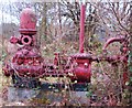
In The Red
Object beside Campsie Road, Milton of Campstie. Could this be a water pump once used in one of the many mills that surrounded the town?
Image: © Lynn M Reid
Taken: 27 Mar 2008
0.04 miles
3
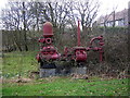
Industrial Relic in Milton of Campsie
This is a pump from the Lilybank Pulp Works (UPC). Water was transmitted by pipe from reservoirs at 'The Well' on the Campsies and discharges after use into the River Glazert.
Image: © Iain Thompson
Taken: 29 Mar 2006
0.04 miles
4
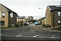
New houses under construction, Milton of Campsie
Beside Lochiel Drive and the A891, Campsie Road.
Image: © Richard Sutcliffe
Taken: 29 Jun 2016
0.05 miles
5
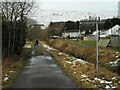
Road to Baldoran Farm
The road follows the west bank of the Brash Burn, before swinging round to the left further on. The sign for the farm is quite difficult to see (top right).
Image: © Richard Sutcliffe
Taken: 25 Feb 2022
0.05 miles
6
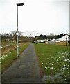
Footpath from Lochiel Drive to Lochalsh Crescent
The footpath runs parallel with the Brash Burn on the left.
Image: © Richard Sutcliffe
Taken: 25 Feb 2022
0.05 miles
7
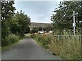
Road to Baldoran Farm
The road follows the west bank of the Brash Burn, before swinging round to the left further on.
Image: © Richard Sutcliffe
Taken: 17 Aug 2022
0.05 miles
8
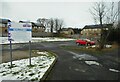
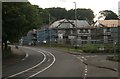
Church car park
Milton of Campsie Parish Church's car park, behind the church. The sign says that those wishing to use the car park do so at their own risk.
Image: © Richard Sutcliffe
Taken: 25 Feb 2022
0.05 miles
9
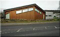
Milton of Campsie Parish Church
A modern Church of Scotland church at the corner of Campsie Road and Lochiel Drive.
Image: © Richard Sutcliffe
Taken: 25 Feb 2022
0.05 miles
10
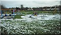
Play area, Milton of Campsie
Beside the recreation ground.
Image: © Richard Sutcliffe
Taken: 25 Feb 2022
0.05 miles