IMAGES TAKEN NEAR TO
Milton Of Campsie, GLASGOW, G66 8EN
Introduction
This page details the photographs taken nearby to G66 8EN by members of the Geograph project.
The Geograph project started in 2005 with the aim of publishing, organising and preserving representative images for every square kilometre of Great Britain, Ireland and the Isle of Man.

There are currently over 7.5m images from over14,400 individuals and you can help contribute to the project by visiting https://www.geograph.org.uk
Image Map
Images are licensed for reuse under creativecommons.org/licenses/by-sa/2.0
Notes
- Clicking on the map will re-center to the selected point.
- The higher the marker number, the further away the image location is from the centre of the postcode.
Image Listing (4 Images Found)
Images are licensed for reuse under creativecommons.org/licenses/by-sa/2.0
Image
Details
Distance
1
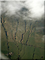
Spouthead from the air
The gorge on the left is that of the Forking Burn
Image: © Thomas Nugent
Taken: 24 Apr 2022
0.07 miles
2
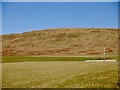
Field, Spouthead
Under the Campsie scarp.
Image: © Richard Webb
Taken: 26 Jan 2023
0.10 miles
3
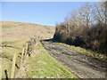
Road to Spouthead
Beneath the Campsie scarp.
Image: © Richard Webb
Taken: 26 Jan 2023
0.10 miles
4
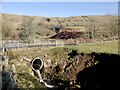
Culvert, Spouthead Burn
Under the road to Shields.
Image: © Richard Webb
Taken: 26 Jan 2023
0.25 miles