IMAGES TAKEN NEAR TO
Poplar Drive, GLASGOW, G66 8DZ
Introduction
This page details the photographs taken nearby to Poplar Drive, G66 8DZ by members of the Geograph project.
The Geograph project started in 2005 with the aim of publishing, organising and preserving representative images for every square kilometre of Great Britain, Ireland and the Isle of Man.

There are currently over 7.5m images from over14,400 individuals and you can help contribute to the project by visiting https://www.geograph.org.uk
Image Map
Images are licensed for reuse under creativecommons.org/licenses/by-sa/2.0
Notes
- Clicking on the map will re-center to the selected point.
- The higher the marker number, the further away the image location is from the centre of the postcode.
Image Listing (11 Images Found)
Images are licensed for reuse under creativecommons.org/licenses/by-sa/2.0
Image
Details
Distance
2
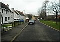
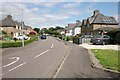
Birdston Road
The houses in this section of Birdston Road are set back from the main road itself.
Image: © Richard Sutcliffe
Taken: 25 Feb 2022
0.16 miles
3
Birdston Road
The houses in this section of Birdston Road are set back from the main road itself.
Image: © Richard Sutcliffe
Taken: 25 Feb 2022
0.17 miles
4
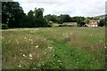
Footpath through the meadow
The meadow is situated between the old railway line and Birdston Road. The houses are on Kincaid Field.
Image: © Richard Sutcliffe
Taken: 14 Jul 2019
0.20 miles
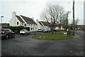
6

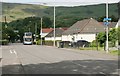
Alder Road, Milton of Campsie
Overlooked by the snow-covered Campsie Fells.
Image: © Richard Sutcliffe
Taken: 25 Feb 2022
0.21 miles
7
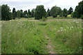
Footpath through the meadow
The meadow is situated between the old railway line and Birdston Road.
Image: © Richard Sutcliffe
Taken: 14 Jul 2019
0.21 miles

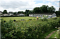
9
Beechtree Terrace, Milton of Campsie
Image: © Richard Sutcliffe
Taken: 14 Jul 2019
0.22 miles
10
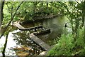
Weir on the Glazert Water
Just downstream from SEPA's monitoring station. For a similar view 9 years previously, see [https://www.geograph.org.uk/photo/2032721].
Image: © Richard Sutcliffe
Taken: 14 Jul 2019
0.23 miles