IMAGES TAKEN NEAR TO
Scott Avenue, GLASGOW, G66 8DH
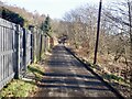
Introduction
This page details the photographs taken nearby to Scott Avenue, G66 8DH by members of the Geograph project.
The Geograph project started in 2005 with the aim of publishing, organising and preserving representative images for every square kilometre of Great Britain, Ireland and the Isle of Man.

There are currently over 7.5m images from over14,400 individuals and you can help contribute to the project by visiting https://www.geograph.org.uk
Image Map
Images are licensed for reuse under creativecommons.org/licenses/by-sa/2.0
Notes
- Clicking on the map will re-center to the selected point.
- The higher the marker number, the further away the image location is from the centre of the postcode.
Image Listing (66 Images Found)
Images are licensed for reuse under creativecommons.org/licenses/by-sa/2.0
Image
Details
Distance
1
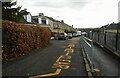
Craighead Road
Craighead Primary School is on the right.
Image: © Richard Sutcliffe
Taken: 25 Feb 2022
0.04 miles
2
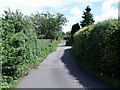
Milton of Campsie, private road
A back lane that leads to Shiels farm and the braes of the Campsies.
Image: © Robert Murray
Taken: 13 Jul 2010
0.05 miles
3
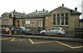
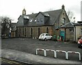
Craighead Library, Craighead Community Centre
Designed by David Woodburn Sturrock, 1902-3 as the local primary school. The building was replaced by a new school next door in 1968 and the old school was then converted into a library and youth centre. It is Category C listed http://portal.historicenvironment.scot/designation/LB49876.
Image: © Richard Sutcliffe
Taken: 25 Feb 2022
0.07 miles
4
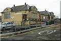
Craighead Library, Craighead Community Centre
Designed by David Woodburn Sturrock, 1902-3 as the local primary school. The building was replaced by a new school next door in 1968 and the old school was then converted into a library and youth centre. It is Category C listed http://portal.historicenvironment.scot/designation/LB49876.
Image: © Richard Sutcliffe
Taken: 25 Feb 2022
0.07 miles
6
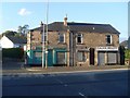
Shops in Milton of Campsie
On Antermony Road, at the top of Birdston Road.
Image: © Stephen Sweeney
Taken: 12 Aug 2010
0.08 miles
7
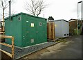
Gas and electricity substations
Baldoran DG gas installation and Scottish Power's Lochiel Drive substation. Beside a footpath and steps from Lochiel Drive to Craighead Road.
Image: © Richard Sutcliffe
Taken: 25 Feb 2022
0.09 miles
8
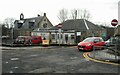
Milton of Campsie Village Hall
On School Lane. Beyond is the former Milton Church (now turned into a residence).
Image: © Richard Sutcliffe
Taken: 25 Feb 2022
0.09 miles
9
Road to Shields
Climbing out of Milton of Campsie.
Image: © Richard Webb
Taken: 26 Jan 2023
0.10 miles
10
Former Milton Church
Built in 1888, the old parish church was designed by David Thomson, a Glasgow architect. The new church at the corner of Lochiel Drive replaced it. The old church has since been converted into residential property.
Image: © Richard Sutcliffe
Taken: 25 Feb 2022
0.10 miles