IMAGES TAKEN NEAR TO
Milton Of Campsie, GLASGOW, G66 8AD
Introduction
This page details the photographs taken nearby to G66 8AD by members of the Geograph project.
The Geograph project started in 2005 with the aim of publishing, organising and preserving representative images for every square kilometre of Great Britain, Ireland and the Isle of Man.

There are currently over 7.5m images from over14,400 individuals and you can help contribute to the project by visiting https://www.geograph.org.uk
Image Map
Images are licensed for reuse under creativecommons.org/licenses/by-sa/2.0
Notes
- Clicking on the map will re-center to the selected point.
- The higher the marker number, the further away the image location is from the centre of the postcode.
Image Listing (7 Images Found)
Images are licensed for reuse under creativecommons.org/licenses/by-sa/2.0
Image
Details
Distance
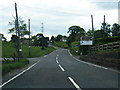
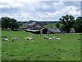
2
Antermony Road
Looking west on the A891.
Image: © Richard Sutcliffe
Taken: 25 Feb 2022
0.15 miles
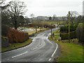
4
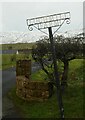
Lochmill Farm sign
Beside Antermony Road.
Image: © Richard Sutcliffe
Taken: 25 Feb 2022
0.21 miles
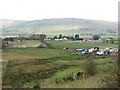
6
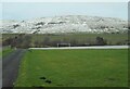
Goal post and Antermony Loch
The goal post is on an area of grass just to the south of Antermony Loch. In the background the Campsie Fells have a dusting of snow. The road leads to Lochmill.
Image: © Richard Sutcliffe
Taken: 25 Feb 2022
0.24 miles