IMAGES TAKEN NEAR TO
Milton Of Campsie, GLASGOW, G66 8AB
Introduction
This page details the photographs taken nearby to G66 8AB by members of the Geograph project.
The Geograph project started in 2005 with the aim of publishing, organising and preserving representative images for every square kilometre of Great Britain, Ireland and the Isle of Man.

There are currently over 7.5m images from over14,400 individuals and you can help contribute to the project by visiting https://www.geograph.org.uk
Image Map
Images are licensed for reuse under creativecommons.org/licenses/by-sa/2.0
Notes
- Clicking on the map will re-center to the selected point.
- The higher the marker number, the further away the image location is from the centre of the postcode.
Image Listing (4 Images Found)
Images are licensed for reuse under creativecommons.org/licenses/by-sa/2.0
Image
Details
Distance
1
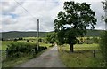
Road to Burniebrae Farm
A cattle grid is to the left of the gate.
Image: © Richard Sutcliffe
Taken: 14 Jul 2019
0.20 miles
2
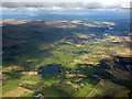
Antermony Loch from the air
The A803 road can be seen leading to Kilsyth.
Image: © Thomas Nugent
Taken: 7 Apr 2016
0.21 miles
3
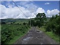
Road to the hills
Passing The Campsie Outdoor Centre and Burniebrae on the way.
Image: © Robert Murray
Taken: 20 Jul 2010
0.22 miles
4
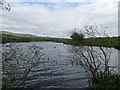
Antermony Loch
Home to a few greylag geese amongst less obvious waterfowl.
Image: © Richard Webb
Taken: 2 May 2014
0.24 miles