IMAGES TAKEN NEAR TO
Craighton Gardens, GLASGOW, G66 7NX
Introduction
This page details the photographs taken nearby to Craighton Gardens, G66 7NX by members of the Geograph project.
The Geograph project started in 2005 with the aim of publishing, organising and preserving representative images for every square kilometre of Great Britain, Ireland and the Isle of Man.

There are currently over 7.5m images from over14,400 individuals and you can help contribute to the project by visiting https://www.geograph.org.uk
Image Map
Images are licensed for reuse under creativecommons.org/licenses/by-sa/2.0
Notes
- Clicking on the map will re-center to the selected point.
- The higher the marker number, the further away the image location is from the centre of the postcode.
Image Listing (7 Images Found)
Images are licensed for reuse under creativecommons.org/licenses/by-sa/2.0
Image
Details
Distance
1
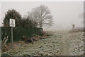
No golf allowed
The sign suggests that this was a problem in the past! The path is in a strip of open ground leading north from the end of Benvue Road. On this day it was well below freezing and slightly foggy.
Image: © Richard Sutcliffe
Taken: 1 Dec 2019
0.02 miles
2
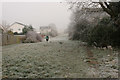
Path between the houses
A strip of open ground leading north from the end of Benvue Road. On this day it was well below freezing and slightly foggy.
Image: © Richard Sutcliffe
Taken: 1 Dec 2019
0.02 miles
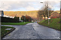
3
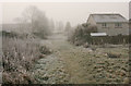
Path to Benvue Road
Looking south towards Benvue Road. On this day it was well below freezing and slightly foggy.
Image: © Richard Sutcliffe
Taken: 1 Dec 2019
0.06 miles
4
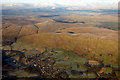
Lennoxtown from the air
Nestling at the foot of the Campsie Fells.
Image: © Thomas Nugent
Taken: 11 Dec 2017
0.13 miles
5
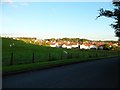
North edge of Lennoxtown
Seen from North Birbiston Road.
Image: © Stephen Sweeney
Taken: 1 Jul 2011
0.18 miles
7
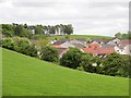
Field off Bencloich Road
Edge of Lennoxtown.
Image: © Richard Webb
Taken: 31 May 2013
0.24 miles