IMAGES TAKEN NEAR TO
Lennoxtown, GLASGOW, G66 7NW
Introduction
This page details the photographs taken nearby to G66 7NW by members of the Geograph project.
The Geograph project started in 2005 with the aim of publishing, organising and preserving representative images for every square kilometre of Great Britain, Ireland and the Isle of Man.

There are currently over 7.5m images from over14,400 individuals and you can help contribute to the project by visiting https://www.geograph.org.uk
Image Map
Images are licensed for reuse under creativecommons.org/licenses/by-sa/2.0
Notes
- Clicking on the map will re-center to the selected point.
- The higher the marker number, the further away the image location is from the centre of the postcode.
Image Listing (7 Images Found)
Images are licensed for reuse under creativecommons.org/licenses/by-sa/2.0
Image
Details
Distance
1
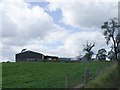
Wetshod Farm
Secluded farm near Milton of Campsie
Image: © Chris Upson
Taken: 31 Aug 2006
0.03 miles
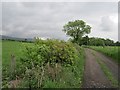
3
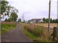
Wetshod Lane
This lane can be walked without hinderance between Birdston and the B822 and though a bit overgrown and forgotten in places it is easily navigated.
Image: © Robert Murray
Taken: 25 Aug 2010
0.07 miles
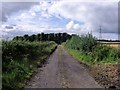
4
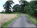
Wetshod Lane
A well surfaced section of the route.
Image: © Richard Webb
Taken: 1 Jun 2012
0.08 miles
5
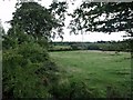
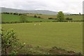
Field at Wetshod
Towards Kirkintilloch golf course.
Image: © Robert Murray
Taken: 25 Aug 2010
0.14 miles
6
Wetshod Lane
Looking toward the B822 Torrance to Lennoxtown road.
Image: © Robert Murray
Taken: 25 Aug 2010
0.19 miles