IMAGES TAKEN NEAR TO
Lennoxtown, GLASGOW, G66 7LQ
Introduction
This page details the photographs taken nearby to G66 7LQ by members of the Geograph project.
The Geograph project started in 2005 with the aim of publishing, organising and preserving representative images for every square kilometre of Great Britain, Ireland and the Isle of Man.

There are currently over 7.5m images from over14,400 individuals and you can help contribute to the project by visiting https://www.geograph.org.uk
Image Map
Images are licensed for reuse under creativecommons.org/licenses/by-sa/2.0
Notes
- Clicking on the map will re-center to the selected point.
- The higher the marker number, the further away the image location is from the centre of the postcode.
Image Listing (33 Images Found)
Images are licensed for reuse under creativecommons.org/licenses/by-sa/2.0
Image
Details
Distance
1
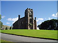
Lennoxtown church
This lovely old church lies at the northern edge of this grid square, Set on its own hilltop with beautiful views and an extensive well kept graveyard it seems a scandal that such a beautiful old building has been left to become a ruin, Does anyone know anything about it?
Image: © Kevin Rae
Taken: 20 Aug 2005
0.05 miles
2
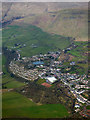
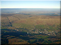
Lennoxtown from the air
Lennoxtown Dam can be seen near the centre of the photo. The B822 Crow Road can be seen climbing the hill in the background.
Image: © Thomas Nugent
Taken: 7 Apr 2016
0.05 miles
3
Lennoxtown from the air
Looking over the Campsie Fells from a Prague bound flight from Glasgow.
Image: © Thomas Nugent
Taken: 4 Dec 2016
0.05 miles
4
Lennoxtown from the air
Looking over the Campsie Fells from a Prague bound flight from Glasgow.
Image: © Thomas Nugent
Taken: 4 Dec 2016
0.05 miles
5
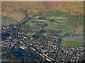
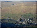
Lennoxtown from the air
Campsie Golf Club can be seen beyond the town. The foot of the B822 Crow Road at Balgrochan can be seen in the top left corner.
Image: © Thomas Nugent
Taken: 11 Dec 2017
0.05 miles
6
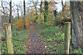
Path to Milton of Campsie
This follows the route of the extinct Strathkelvin Railway.
Image: © Steven Brown
Taken: 9 Nov 2010
0.08 miles
7
Speed limit sign, South Brae
Pre - Worboys signage in Lennoxtown.
Image: © Richard Webb
Taken: 31 May 2013
0.11 miles
8
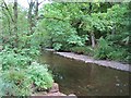
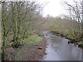
Glazart Water, Lennoxtown
Along with the Luggie Water, this is one of the main contributors to Glasgow's River Kelvin.
Image: © Richard Webb
Taken: 1 Jun 2012
0.12 miles
9
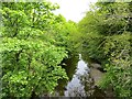
Glazart Water, Lennoxtown
View from the bridge at the foot of South Brae.
Image: © Richard Webb
Taken: 31 May 2013
0.12 miles