IMAGES TAKEN NEAR TO
Lennoxtown, GLASGOW, G66 7LG
Introduction
This page details the photographs taken nearby to G66 7LG by members of the Geograph project.
The Geograph project started in 2005 with the aim of publishing, organising and preserving representative images for every square kilometre of Great Britain, Ireland and the Isle of Man.

There are currently over 7.5m images from over14,400 individuals and you can help contribute to the project by visiting https://www.geograph.org.uk
Image Map
Images are licensed for reuse under creativecommons.org/licenses/by-sa/2.0
Notes
- Clicking on the map will re-center to the selected point.
- The higher the marker number, the further away the image location is from the centre of the postcode.
Image Listing (8 Images Found)
Images are licensed for reuse under creativecommons.org/licenses/by-sa/2.0
Image
Details
Distance
1
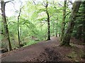
Baldow Plantation
A steep path descends the slopes above the site of Lennox Hospital.
Image: © Richard Webb
Taken: 31 May 2013
0.13 miles
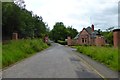
3
South Gate Lodge, Lennox Castle Hospital
Image: © Texas Radio and The Big Beat
Taken: 17 Jul 2011
0.15 miles
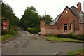
4
Gate, Lennox Castle Hospital
Lennox Castle Hospital was opened in 1936 as Lennox Castle Certified Institution for Mental Defectives and closed in 2002. Part of the site was developed by Celtic FC as a training ground.
Image: © Richard Webb
Taken: 31 May 2013
0.15 miles
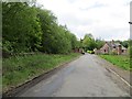
5
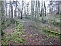
Old road, Drum Plantation
Ruined parallel dykes in steep woodland above the South Lodge gate.
Image: © Richard Webb
Taken: 26 Jan 2023
0.19 miles
6
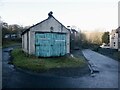
Shed, Netherton Hill
With an old siren on top.
Image: © Richard Webb
Taken: 26 Jan 2023
0.20 miles
7
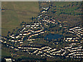
Lennoxtown from the air
The Balgrochan area of the town, at the foot of the B822 Crow Road.
Image: © Thomas Nugent
Taken: 4 Dec 2016
0.24 miles
8
![Remains, Culloch Slap Lime Works [2]](https://s0.geograph.org.uk/geophotos/04/57/23/4572384_aa134972_120x120.jpg)
Remains, Culloch Slap Lime Works [2]
There was an old 'Level situated where the subsidence is which was connected to the main works by a tramway.
Image: © Robert Murray
Taken: 15 Jul 2015
0.25 miles