IMAGES TAKEN NEAR TO
Service Street, GLASGOW, G66 7JP
Introduction
This page details the photographs taken nearby to Service Street, G66 7JP by members of the Geograph project.
The Geograph project started in 2005 with the aim of publishing, organising and preserving representative images for every square kilometre of Great Britain, Ireland and the Isle of Man.

There are currently over 7.5m images from over14,400 individuals and you can help contribute to the project by visiting https://www.geograph.org.uk
Image Map
Images are licensed for reuse under creativecommons.org/licenses/by-sa/2.0
Notes
- Clicking on the map will re-center to the selected point.
- The higher the marker number, the further away the image location is from the centre of the postcode.
Image Listing (61 Images Found)
Images are licensed for reuse under creativecommons.org/licenses/by-sa/2.0
Image
Details
Distance
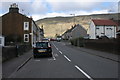
1
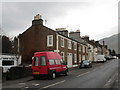
Cottages on Crosshill Street, Lennoxtown
Image: © Jonathan Thacker
Taken: 22 Nov 2018
0.04 miles
2
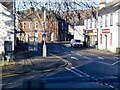
Lennoxtown
Foot of the Crow Road climb.
Image: © Richard Webb
Taken: 26 Jan 2023
0.04 miles
3
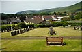
View over the cemetery
This is just a small part of the large cemetery surrounding the old parish church. In the distance is Campsie Glen.
Image: © Richard Sutcliffe
Taken: 31 Jul 2020
0.05 miles
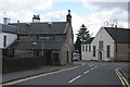
4
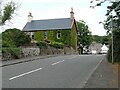
House on Service Street, Lennoxtown
The house on Service Street (A891) is covered in either Virginia creeper or Boston ivy.
Image: © Richard Sutcliffe
Taken: 29 Jul 2021
0.05 miles
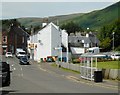
5
Crosshill Street, Lennoxtown
Crosshill Street (B822) becomes Crow Road, which crosses the Campie Fells (in the distance) and Lennox Hills to Fintry.
Image: © Richard Sutcliffe
Taken: 28 Mar 2016
0.05 miles
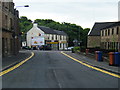
6
Swan Inn, Lennoxtown
Rear of the Swan Inn. One of three hostelries in Lennoxtown. At junction of Main Street and Crosshill Street.
Image: © Richard Sutcliffe
Taken: 28 Mar 2016
0.05 miles
9
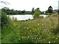
Wildflower meadow, Whitefield Pond
The wildflower meadows were sown as part of upgrade works to the area around the lade leading into the pond, carried out by East Dunbartonshire Council.
Image: © Richard Sutcliffe
Taken: 29 Jul 2021
0.08 miles
10
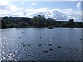
Lennoxtown, Whitefield Dam
Dug out and formed in the early nineteenth century to store water for the Lennox Mill Printworks.
The pond is fed from a series of drains coming off the Campsies which eventually are channelled into a small canal which enters the pond from the north. The overflow leaves by a weir situated at the north east corner.
Image: © Robert Murray
Taken: 5 Sep 2011
0.08 miles