IMAGES TAKEN NEAR TO
St. Machans Way, GLASGOW, G66 7GG
Introduction
This page details the photographs taken nearby to St. Machans Way, G66 7GG by members of the Geograph project.
The Geograph project started in 2005 with the aim of publishing, organising and preserving representative images for every square kilometre of Great Britain, Ireland and the Isle of Man.

There are currently over 7.5m images from over14,400 individuals and you can help contribute to the project by visiting https://www.geograph.org.uk
Image Map
Images are licensed for reuse under creativecommons.org/licenses/by-sa/2.0
Notes
- Clicking on the map will re-center to the selected point.
- The higher the marker number, the further away the image location is from the centre of the postcode.
Image Listing (52 Images Found)
Images are licensed for reuse under creativecommons.org/licenses/by-sa/2.0
Image
Details
Distance
1
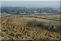
View towards Lennoxtown
St Machan's Primary School is the large building near the centre. Crosshouse Cottage is bottom right.
Image: © Richard Sutcliffe
Taken: 24 Mar 2022
0.02 miles
2
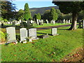
A part of the large cemetery at the High Kirk of Campsie, Lennoxtown
Looking northward.
Image: © Peter Wood
Taken: 5 Oct 2017
0.11 miles
3
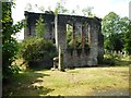
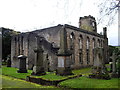
Back of the old church
The High Church of Campsie is Category A listed. Built in 1828 (David Hamilton, Architect), it was in use as the parish church until 1976. On the night of 24 August 1984 a fire raged through the building causing extensive damage to most of the interior and the roof. More recently the Lennoxtown Initiative has stabilised the ruin and restored the clock. There is a great deal of vegetation grown both within and on the fabric of the building, which should probably be removed.
Image: © Richard Sutcliffe
Taken: 31 Jul 2020
0.12 miles
4
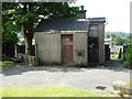
Small building in the graveyard
Probably the grave digger's bothy. The steps on the right lead down to a lower section of the cemetery.
Image: © Richard Sutcliffe
Taken: 31 Jul 2020
0.12 miles
5
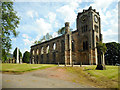
Disused parish church of Campsie, Lennoxtown
In this churchyard are buried Norman MacLeod, known as Caraid nan Gaidheal (friend of the Highlanders), minister of this church, then of St Columba's the Gaelic speaking church in Glasgow, also his son Norman MacLeod, minister of the Barony church in Glasgow, noted for his concern for the poor.
Image: © John Lord
Taken: 6 Oct 2011
0.13 miles
6
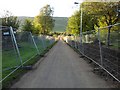
Public path behind Lennoxtown
A lot of work going on around here - I think it may be a new housing development.
Image: © Stephen Sweeney
Taken: 1 Jul 2011
0.13 miles
7
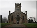
Former parish church, Lennoxtown
The High Church of Campsie is Category A listed. Built in 1828 (David Hamilton, Architect), it was in use as the parish church until 1976. On the night of 24 August 1984 a fire raged through the building causing extensive damage to most of the interior and the roof. More recently the Lennoxtown Initiative has stabilised the ruin and restored the clock.
Image: © Richard Sutcliffe
Taken: 31 Jul 2020
0.13 miles
8
The former High Kirk, Lennoxtown
Now just a shell.
Image: © Jonathan Thacker
Taken: 22 Nov 2018
0.14 miles
9
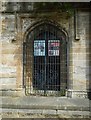
Doors to the old church
Ornamental metal gates in front of the wooden doors to the High Church of Campsie Image The information panels on the door describe how the construction of the church came about between 1826 and 1829; and the destruction of the roof and interior by fire in 1984.
Image: © Richard Sutcliffe
Taken: 31 Jul 2020
0.14 miles
10

Driveway up to the old church
Looking from the war memorial on Main Street up to the old church Image
Image: © Richard Sutcliffe
Taken: 31 Jul 2020
0.14 miles