IMAGES TAKEN NEAR TO
Warren Walk, GLASGOW, G66 7EU
Introduction
This page details the photographs taken nearby to Warren Walk, G66 7EU by members of the Geograph project.
The Geograph project started in 2005 with the aim of publishing, organising and preserving representative images for every square kilometre of Great Britain, Ireland and the Isle of Man.

There are currently over 7.5m images from over14,400 individuals and you can help contribute to the project by visiting https://www.geograph.org.uk
Image Map
Images are licensed for reuse under creativecommons.org/licenses/by-sa/2.0
Notes
- Clicking on the map will re-center to the selected point.
- The higher the marker number, the further away the image location is from the centre of the postcode.
Image Listing (20 Images Found)
Images are licensed for reuse under creativecommons.org/licenses/by-sa/2.0
Image
Details
Distance
2
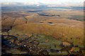
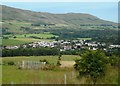
Lennoxtown from the air
Nestling at the foot of the Campsie Fells.
Image: © Thomas Nugent
Taken: 11 Dec 2017
0.07 miles
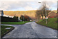
3
Holyknowe Road
View up a residential street towards the Campsie Fell escarpment.
Image: © Richard Webb
Taken: 1 Jun 2012
0.12 miles
4
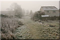
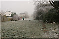
Path to Benvue Road
Looking south towards Benvue Road. On this day it was well below freezing and slightly foggy.
Image: © Richard Sutcliffe
Taken: 1 Dec 2019
0.13 miles
5
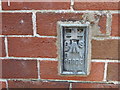
Ordnance Survey Flush Bracket S8925
This can be found on the wall of a private dwelling at Rowantree Place, Lennoxtown. The benchmark height is recorded as being 61.605 metres above sea level. For more detail see : http://www.bench-marks.org.uk/bm21297
Image: © Peter Wood
Taken: 5 Oct 2017
0.15 miles
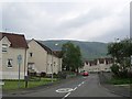
6
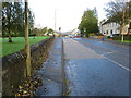
Milton Road (A891) in Lennoxtown
Looking north-westward.
Image: © Peter Wood
Taken: 5 Oct 2017
0.16 miles
7
Path between the houses
A strip of open ground leading north from the end of Benvue Road. On this day it was well below freezing and slightly foggy.
Image: © Richard Sutcliffe
Taken: 1 Dec 2019
0.19 miles
8
Lennoxtown from South Brae
The Campsie Fells are behind.
Image: © Richard Sutcliffe
Taken: 31 Jul 2020
0.19 miles
9
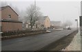
Houses at the edge of Lennoxtown
Beside the A891 on a frosty and foggy day.
Image: © Richard Sutcliffe
Taken: 1 Dec 2019
0.20 miles
10
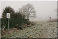
No golf allowed
The sign suggests that this was a problem in the past! The path is in a strip of open ground leading north from the end of Benvue Road. On this day it was well below freezing and slightly foggy.
Image: © Richard Sutcliffe
Taken: 1 Dec 2019
0.20 miles