IMAGES TAKEN NEAR TO
Elm Street, GLASGOW, G66 7EA
Introduction
This page details the photographs taken nearby to Elm Street, G66 7EA by members of the Geograph project.
The Geograph project started in 2005 with the aim of publishing, organising and preserving representative images for every square kilometre of Great Britain, Ireland and the Isle of Man.

There are currently over 7.5m images from over14,400 individuals and you can help contribute to the project by visiting https://www.geograph.org.uk
Image Map
Images are licensed for reuse under creativecommons.org/licenses/by-sa/2.0
Notes
- Clicking on the map will re-center to the selected point.
- The higher the marker number, the further away the image location is from the centre of the postcode.
Image Listing (28 Images Found)
Images are licensed for reuse under creativecommons.org/licenses/by-sa/2.0
Image
Details
Distance
1
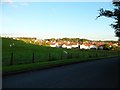
North edge of Lennoxtown
Seen from North Birbiston Road.
Image: © Stephen Sweeney
Taken: 1 Jul 2011
0.05 miles
2
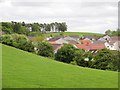
Field off Bencloich Road
Edge of Lennoxtown.
Image: © Richard Webb
Taken: 31 May 2013
0.10 miles
3
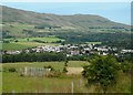
Lennoxtown from South Brae
The Campsie Fells are behind.
Image: © Richard Sutcliffe
Taken: 31 Jul 2020
0.15 miles
4
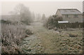
Path to Benvue Road
Looking south towards Benvue Road. On this day it was well below freezing and slightly foggy.
Image: © Richard Sutcliffe
Taken: 1 Dec 2019
0.16 miles
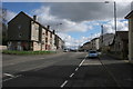
5
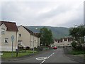
Holyknowe Road
View up a residential street towards the Campsie Fell escarpment.
Image: © Richard Webb
Taken: 1 Jun 2012
0.17 miles
6
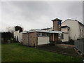
Free Church of Scotland, Lennoxtown
Image: © Jonathan Thacker
Taken: 22 Nov 2018
0.18 miles
8
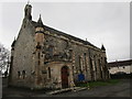
St, Machan's Roman Catholic Church
Dates from 1846.
Image: © Jonathan Thacker
Taken: 22 Nov 2018
0.18 miles

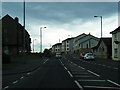
10
Main Street, Lennoxtown
Looking south east.
Image: © Richard Sutcliffe
Taken: 28 Mar 2016
0.19 miles