IMAGES TAKEN NEAR TO
Bencloich Place, GLASGOW, G66 7AU
Introduction
This page details the photographs taken nearby to Bencloich Place, G66 7AU by members of the Geograph project.
The Geograph project started in 2005 with the aim of publishing, organising and preserving representative images for every square kilometre of Great Britain, Ireland and the Isle of Man.

There are currently over 7.5m images from over14,400 individuals and you can help contribute to the project by visiting https://www.geograph.org.uk
Image Map
Images are licensed for reuse under creativecommons.org/licenses/by-sa/2.0
Notes
- Clicking on the map will re-center to the selected point.
- The higher the marker number, the further away the image location is from the centre of the postcode.
Image Listing (47 Images Found)
Images are licensed for reuse under creativecommons.org/licenses/by-sa/2.0
Image
Details
Distance
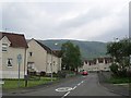
1
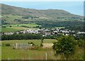
Lennoxtown from South Brae
The Campsie Fells are behind.
Image: © Richard Sutcliffe
Taken: 31 Jul 2020
0.04 miles
2
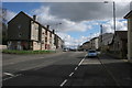
Main Street, Lennoxtown
Looking south east.
Image: © Richard Sutcliffe
Taken: 28 Mar 2016
0.05 miles
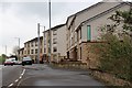

6
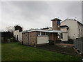
Free Church of Scotland, Lennoxtown
Image: © Jonathan Thacker
Taken: 22 Nov 2018
0.08 miles
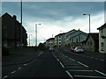
7
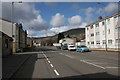
Main Street, Lennoxtown
Looking north west.
Image: © Richard Sutcliffe
Taken: 28 Mar 2016
0.10 miles
8
Milton Road (A891) in Lennoxtown
Looking north-westward.
Image: © Peter Wood
Taken: 5 Oct 2017
0.11 miles
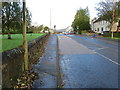
9
Holyknowe Road
View up a residential street towards the Campsie Fell escarpment.
Image: © Richard Webb
Taken: 1 Jun 2012
0.12 miles
10
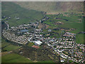
Lennoxtown from the air
At the foot of the Campsie Fells, the Crow Road can be seen ascending the hill in the top left corner.
Image: © Thomas Nugent
Taken: 7 Apr 2016
0.12 miles