IMAGES TAKEN NEAR TO
Haughhead, Strathblane Road, GLASGOW, G66 7AN
Introduction
This page details the photographs taken nearby to Haughhead, Strathblane Road, G66 7AN by members of the Geograph project.
The Geograph project started in 2005 with the aim of publishing, organising and preserving representative images for every square kilometre of Great Britain, Ireland and the Isle of Man.

There are currently over 7.5m images from over14,400 individuals and you can help contribute to the project by visiting https://www.geograph.org.uk
Image Map
Images are licensed for reuse under creativecommons.org/licenses/by-sa/2.0
Notes
- Clicking on the map will re-center to the selected point.
- The higher the marker number, the further away the image location is from the centre of the postcode.
Image Listing (53 Images Found)
Images are licensed for reuse under creativecommons.org/licenses/by-sa/2.0
Image
Details
Distance
2
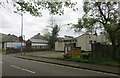
Former Haughhead Inn
Former public house, closed for several years.
Image: © Richard Sutcliffe
Taken: 24 Mar 2022
0.01 miles
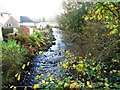
4
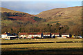
Haughhead Houses
A view of Haughhead with the Fin Glen in the background.
Image: © Ron Shephard
Taken: 9 Aug 2014
0.02 miles
5
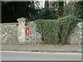
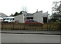
Postbox, Haughhead
GR wall box beside the A891. Postbox No: G66 585D.
Image: © Richard Sutcliffe
Taken: 24 Mar 2022
0.03 miles
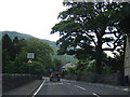
7
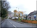
Haughhead village
Small village on the A891 Strathblane to Lennoxtown road.
Image: © Robert Murray
Taken: 1 Nov 2011
0.03 miles
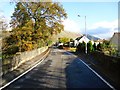
9
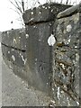
OS cutmark
On the bridge over the Fin Burn.
Image: © Richard Sutcliffe
Taken: 24 Mar 2022
0.04 miles
10
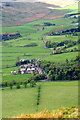
The Village of Haughhead
Haughhead taken from the Campsie Fells looking west.
Image: © Ron Shephard
Taken: 15 Jul 2014
0.04 miles