IMAGES TAKEN NEAR TO
Craigie Park, GLASGOW, G66 5NU
Introduction
This page details the photographs taken nearby to Craigie Park, G66 5NU by members of the Geograph project.
The Geograph project started in 2005 with the aim of publishing, organising and preserving representative images for every square kilometre of Great Britain, Ireland and the Isle of Man.

There are currently over 7.5m images from over14,400 individuals and you can help contribute to the project by visiting https://www.geograph.org.uk
Image Map
Images are licensed for reuse under creativecommons.org/licenses/by-sa/2.0
Notes
- Clicking on the map will re-center to the selected point.
- The higher the marker number, the further away the image location is from the centre of the postcode.
Image Listing (28 Images Found)
Images are licensed for reuse under creativecommons.org/licenses/by-sa/2.0
Image
Details
Distance
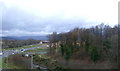
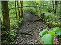
1
Small burn in Millersneuk, Kirkintilloch
Not named on any of the OS maps.
Image: © Stephen Sweeney
Taken: 4 Sep 2009
0.07 miles
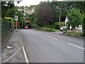
2
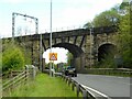
Railway viaduct
The Glasgow to Edinburgh railway line crosses the A806, Initiative Road.
Image: © Richard Sutcliffe
Taken: 10 May 2022
0.07 miles
3
Railway viaduct
Two walkers on the Bothlin Burn Pathway shelter under the viaduct as a heavy shower passes over. The viaduct (officially Bridge 070/105) carries the Glasgow to Edinburgh line over the Bothlin Burn and the A806.
Image: © Richard Sutcliffe
Taken: 10 May 2022
0.09 miles
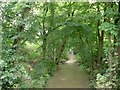
5
Canal feeder
A silted up channel that fed the Forth and Clyde Canal in Kirkintilloch. The water came from the Bothlin Burn about 600 metres to the southeast at Bothlin Bank.
Image: © Richard Sutcliffe
Taken: 10 May 2022
0.12 miles
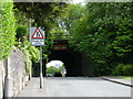
6
Low bridge approaching
Railway bridge over Easter Garngaber Road.
Image: © Stephen Sweeney
Taken: 4 Sep 2009
0.12 miles
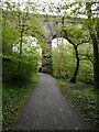
7
Millersneuk Railway Bridge
The main Edinburgh to Glasgow rail link crosses this road, and is one of the busiest stretches of track in the country.
Image: © Raymond Okonski
Taken: 22 May 2007
0.14 miles
8

The Bothlin Burn
Looking upstream from the Menzies Drive bridge.
Image: © Richard Sutcliffe
Taken: 10 May 2022
0.16 miles
9
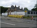
The Larkfield Centre
Mental Health clinic in Lenzie, Kirkintilloch.
Image: © Stephen Sweeney
Taken: 4 Sep 2009
0.16 miles
10
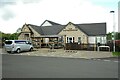
The Old Gatehouse
Pub restaurant at the junction of Initiative Road (A806) and Woodilee Road. It is built on the site of, and includes some of the original stonework from the former gatehouse to Woodilee Hospital. The original building dated from 1874, the new one was constructed in 2017.
Image: © Richard Sutcliffe
Taken: 10 May 2022
0.16 miles