IMAGES TAKEN NEAR TO
Burnbrae Road, GLASGOW, G66 5LH
Introduction
This page details the photographs taken nearby to Burnbrae Road, G66 5LH by members of the Geograph project.
The Geograph project started in 2005 with the aim of publishing, organising and preserving representative images for every square kilometre of Great Britain, Ireland and the Isle of Man.

There are currently over 7.5m images from over14,400 individuals and you can help contribute to the project by visiting https://www.geograph.org.uk
Image Map
Images are licensed for reuse under creativecommons.org/licenses/by-sa/2.0
Notes
- Clicking on the map will re-center to the selected point.
- The higher the marker number, the further away the image location is from the centre of the postcode.
Image Listing (12 Images Found)
Images are licensed for reuse under creativecommons.org/licenses/by-sa/2.0
Image
Details
Distance
1
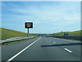
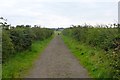
The Road to Blacklands
Looking south west
Image: © Chris Upson
Taken: 26 Feb 2006
0.04 miles
2
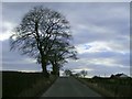
Unclassified road east of Blacklands
Image: © Elliott Simpson
Taken: 18 Nov 2017
0.13 miles
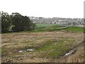
3
Bog south of Lenzie
This wetland doesn't seem to have a name on local maps.
Image: © Robert Murray
Taken: 3 Oct 2015
0.14 miles
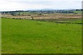
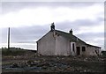
5
Growing grass near edge of field
Lindsaybeg Road and a derelict Netherhouses steading in the background.
Image: © Robert Murray
Taken: 12 Jun 2010
0.18 miles
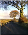
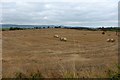
7
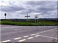
Cross Roads on the border
Burbrae Road and Lindsaybeg Road on the hill north of Chryston where two counties meet.
Image: © Robert Murray
Taken: 12 Jun 2010
0.20 miles
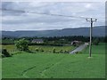
9
Lindsaybeg Road
Lindsaybeg Road is now on an embankment as it has to cross the new M80. The remaining land after the road construction was stubble covered.
Image: © Richard Webb
Taken: 14 Oct 2011
0.22 miles