IMAGES TAKEN NEAR TO
Andrew Avenue, GLASGOW, G66 5HF
Introduction
This page details the photographs taken nearby to Andrew Avenue, G66 5HF by members of the Geograph project.
The Geograph project started in 2005 with the aim of publishing, organising and preserving representative images for every square kilometre of Great Britain, Ireland and the Isle of Man.

There are currently over 7.5m images from over14,400 individuals and you can help contribute to the project by visiting https://www.geograph.org.uk
Image Map
Images are licensed for reuse under creativecommons.org/licenses/by-sa/2.0
Notes
- Clicking on the map will re-center to the selected point.
- The higher the marker number, the further away the image location is from the centre of the postcode.
Image Listing (12 Images Found)
Images are licensed for reuse under creativecommons.org/licenses/by-sa/2.0
Image
Details
Distance
1
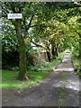
Private road to Lenzie Tennis Club
Off Lindsaybeg Road.
Image: © Stephen Sweeney
Taken: 4 Sep 2009
0.12 miles
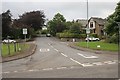
2
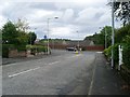
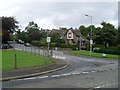
Mini-roundabout at Auchinloch Road
Looking down from Lenzie Road.
Image: © Stephen Sweeney
Taken: 4 Sep 2009
0.12 miles
3
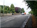
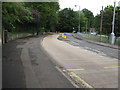
Crosshill Road, Lenzie
A rare urban section of the B819, as the majority of the route is in the countryside.
Image: © Stephen Sweeney
Taken: 4 Sep 2009
0.12 miles
4
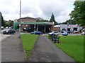
BP station, Lenzie
On Auchinloch Road at Lindsaybeg Road.
Image: © Stephen Sweeney
Taken: 4 Sep 2009
0.13 miles
6
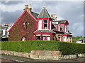
Lenzie Townhouse
House at junction of Glenbank Road and Glenhead Road, covered with red ivy
Image: © Chris Upson
Taken: 25 Sep 2005
0.15 miles
7
Auchinloch Road, Lenzie
Looking roughly north along Auchinloch Road, Lenzie in the direction of Kirkintilloch.
Image: © Andrew Reid
Taken: 25 Aug 2011
0.15 miles
9
Victoria Road, Lenzie
Junction with Crosshill Road.
Image: © Richard Sutcliffe
Taken: 20 Jul 2016
0.16 miles
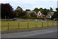
10
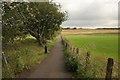
Footpath beside Lenzie Golf Course
The golf course is to the left of the path.
Image: © Richard Sutcliffe
Taken: 20 Jul 2016
0.21 miles