IMAGES TAKEN NEAR TO
Stepps Road, GLASGOW, G66 5DH
Introduction
This page details the photographs taken nearby to Stepps Road, G66 5DH by members of the Geograph project.
The Geograph project started in 2005 with the aim of publishing, organising and preserving representative images for every square kilometre of Great Britain, Ireland and the Isle of Man.

There are currently over 7.5m images from over14,400 individuals and you can help contribute to the project by visiting https://www.geograph.org.uk
Image Map
Images are licensed for reuse under creativecommons.org/licenses/by-sa/2.0
Notes
- Clicking on the map will re-center to the selected point.
- The higher the marker number, the further away the image location is from the centre of the postcode.
Image Listing (10 Images Found)
Images are licensed for reuse under creativecommons.org/licenses/by-sa/2.0
Image
Details
Distance
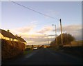
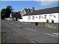
2
Golden Pheasant
On Stepps Road at the junction with Langmuirhead Road and Auchinloch Road.
Image: © G Laird
Taken: 22 Oct 2011
0.05 miles
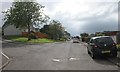
4
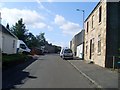
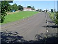
Langmuirhead Road
The main road through the village of Auchinloch.
Image: © Stephen Sweeney
Taken: 9 Sep 2009
0.11 miles
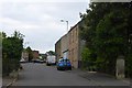
5
Houses in Auchinloch
On Langmuirhead Road.
Image: © Stephen Sweeney
Taken: 9 Sep 2009
0.11 miles
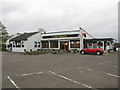
6
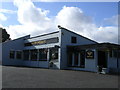
Golden Pheasant
Pub at Auchinloch on Stepps Road
Image: © Chris Upson
Taken: 25 Sep 2005
0.14 miles
7
Gadloch Avenue, Auchinloch
The road to the left is Gadloch View.
Image: © Richard Sutcliffe
Taken: 20 Jul 2016
0.15 miles
8
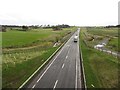
A806
The A806 now bypasses Lenzie. View from an overbridge.
Image: © Richard Webb
Taken: 14 Oct 2011
0.23 miles
10
Uphill to houses by Langmuirhead Road
In Auchinloch.
Image: © Stephen Sweeney
Taken: 9 Sep 2009
0.24 miles