IMAGES TAKEN NEAR TO
Sycamore Avenue, GLASGOW, G66 4NY
Introduction
This page details the photographs taken nearby to Sycamore Avenue, G66 4NY by members of the Geograph project.
The Geograph project started in 2005 with the aim of publishing, organising and preserving representative images for every square kilometre of Great Britain, Ireland and the Isle of Man.

There are currently over 7.5m images from over14,400 individuals and you can help contribute to the project by visiting https://www.geograph.org.uk
Image Map
Images are licensed for reuse under creativecommons.org/licenses/by-sa/2.0
Notes
- Clicking on the map will re-center to the selected point.
- The higher the marker number, the further away the image location is from the centre of the postcode.
Image Listing (8 Images Found)
Images are licensed for reuse under creativecommons.org/licenses/by-sa/2.0
Image
Details
Distance
1

Lenzie Union Parish Church
At the corner of Kirkintilloch Road (B757) and Moncrieff Avenue.
Image: © G Laird
Taken: 24 Jun 2012
0.16 miles
3
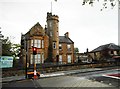
The Tower Nursery, Lenzie
The Tower was built about 1900 and is Category C listed.
Image: © Richard Sutcliffe
Taken: 17 Jun 2019
0.18 miles
4
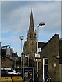
Lenzie church spire
View from the station
Image: © Richard Webb
Taken: 30 Oct 2015
0.20 miles
5
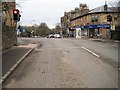
Kirkintilloch Road, Lenzie
Shops and railway station in the distance.
Image: © Nigel Thompson
Taken: 9 Feb 2017
0.20 miles
6
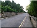
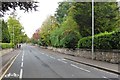
Garngaber Avenue
Runs from Millersneuk to Lenzie.
Image: © Stephen Sweeney
Taken: 4 Sep 2009
0.21 miles
7
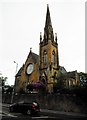
Lenzie Old Parish Church
A Category C listed church [http://portal.historicenvironment.scot/designation/LB4400], dating from 1874.
Image: © Richard Sutcliffe
Taken: 17 Jun 2019
0.21 miles
8
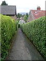
Cycle path down to Woodside Avenue
In Kirkintilloch.
Image: © Stephen Sweeney
Taken: 4 Sep 2009
0.25 miles