IMAGES TAKEN NEAR TO
Gallowhill Road, GLASGOW, G66 4AJ
Introduction
This page details the photographs taken nearby to Gallowhill Road, G66 4AJ by members of the Geograph project.
The Geograph project started in 2005 with the aim of publishing, organising and preserving representative images for every square kilometre of Great Britain, Ireland and the Isle of Man.

There are currently over 7.5m images from over14,400 individuals and you can help contribute to the project by visiting https://www.geograph.org.uk
Image Map
Images are licensed for reuse under creativecommons.org/licenses/by-sa/2.0
Notes
- Clicking on the map will re-center to the selected point.
- The higher the marker number, the further away the image location is from the centre of the postcode.
Image Listing (24 Images Found)
Images are licensed for reuse under creativecommons.org/licenses/by-sa/2.0
Image
Details
Distance
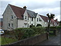

7
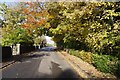
Beech Road
Outside St Cyprian's Church.
Image: © Richard Webb
Taken: 30 Oct 2015
0.14 miles
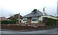
8
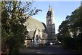
St Cyprian
Episcopalian church, Beech Road, Lenzie.
Image: © Richard Webb
Taken: 30 Oct 2015
0.15 miles
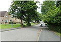
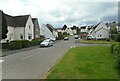
10
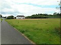
The Greens
The recreation ground on the right (The Greens) has a red blaes football pitch. The path runs between Parkburn Avenue and Westergreens Avenue.
Image: © Richard Sutcliffe
Taken: 5 Jul 2023
0.18 miles