IMAGES TAKEN NEAR TO
Woodilee Road, GLASGOW, G66 3TU
Introduction
This page details the photographs taken nearby to Woodilee Road, G66 3TU by members of the Geograph project.
The Geograph project started in 2005 with the aim of publishing, organising and preserving representative images for every square kilometre of Great Britain, Ireland and the Isle of Man.

There are currently over 7.5m images from over14,400 individuals and you can help contribute to the project by visiting https://www.geograph.org.uk
Image Map
Images are licensed for reuse under creativecommons.org/licenses/by-sa/2.0
Notes
- Clicking on the map will re-center to the selected point.
- The higher the marker number, the further away the image location is from the centre of the postcode.
Image Listing (7 Images Found)
Images are licensed for reuse under creativecommons.org/licenses/by-sa/2.0
Image
Details
Distance
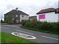
1
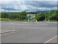
Roundabout on Woodlee Road, Kirkintilloch
Looking north at a new roundabout with the Kilsyth Hills in the background.
Image: © G Laird
Taken: 24 Jun 2012
0.09 miles
2
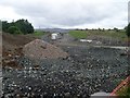
Construction work on the edge of Kirkintilloch
Constructing a new main road on the edge of the town
Image: © Stephen Sweeney
Taken: 4 Sep 2009
0.17 miles
3
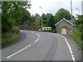
Approaching a sharp bend on Woodilee Road
From the south.
Image: © Stephen Sweeney
Taken: 4 Sep 2009
0.17 miles
5
Florist Gump
Humorously-named flower shop on Loch Road, Kirkintilloch.
Image: © Stephen Sweeney
Taken: 4 Sep 2009
0.18 miles
6
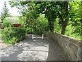
Closed off road, Woodlee
A very narrow road now closed to vehicles.
Image: © Richard Webb
Taken: 31 May 2013
0.20 miles
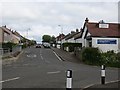
7
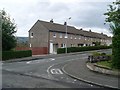
Oxgang Place
Residential street in Oxgang, Kirkintilloch.
Image: © Stephen Sweeney
Taken: 4 Sep 2009
0.23 miles