IMAGES TAKEN NEAR TO
Carresbrook Place, GLASGOW, G66 3TP
Introduction
This page details the photographs taken nearby to Carresbrook Place, G66 3TP by members of the Geograph project.
The Geograph project started in 2005 with the aim of publishing, organising and preserving representative images for every square kilometre of Great Britain, Ireland and the Isle of Man.

There are currently over 7.5m images from over14,400 individuals and you can help contribute to the project by visiting https://www.geograph.org.uk
Image Map
Images are licensed for reuse under creativecommons.org/licenses/by-sa/2.0
Notes
- Clicking on the map will re-center to the selected point.
- The higher the marker number, the further away the image location is from the centre of the postcode.
Image Listing (12 Images Found)
Images are licensed for reuse under creativecommons.org/licenses/by-sa/2.0
Image
Details
Distance
1
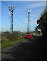
Phone masts
Beside Chryston Road, Fauldhead.
Image: © Richard Sutcliffe
Taken: 18 Sep 2020
0.05 miles
2

New houses
The houses are part of a recent development adjacent to Market Road. In the foreground the rosebay willowherb is going to seed.
Image: © Richard Sutcliffe
Taken: 18 Sep 2020
0.07 miles
3
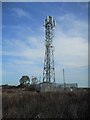
Phone mast
One of two phone masts beside Chryston Road, Fauldhead.
Image: © Richard Sutcliffe
Taken: 18 Sep 2020
0.08 miles
4
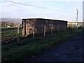
Relic of War
Second World War air raid shelter in Chryston Road near to where Woodilee hospital stood. There is another survivor nearby both would have been built to provide shelter for staff.
Image: © Robert Murray
Taken: 8 Nov 2009
0.08 miles
5
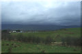
Fauldhead from the west
The water tower is clearly visible.
Image: © Stephen Sweeney
Taken: 15 Dec 2011
0.10 miles
6
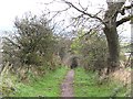
Green lane
A road which now appears to be a popular path.
Image: © Richard Webb
Taken: 14 Oct 2011
0.12 miles
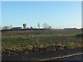
7
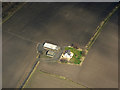
Wallflat from the air
Amidst ploughed fields on the outskirts of Lenzie.
Image: © Thomas Nugent
Taken: 7 Apr 2016
0.17 miles
9
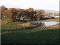
The Mound and the Pond
At the hamlet of Duntiblae near Waterside.
Image: © Robert Murray
Taken: 8 Nov 2009
0.23 miles
10
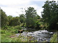
River Luggie at Waterside, near Kirkintilloch
Waterside is a small village, formerly a centre of weaving, on the outskirts of Kirkintilloch
Image: © Brian D Osborne
Taken: 18 Sep 2005
0.24 miles